A Photographer’s First Look at Alaska’s Most Complete Wilderness — Where Every Landscape the State Offers Exists in One Park
When planning a visit to America’s national parks, the Alaska parks occupy a category that the lower 48 cannot replicate. They are larger, more remote, more demanding, and more rewarding in a proportion that remains consistent across all of them. Lake Clark National Park and Preserve sits at the far end of that spectrum — not because it is the most famous Alaska park or the most visited, but because it contains more of what Alaska offers in a single park boundary than any other unit in the system.
Lake Clark covers 4 million acres of the Alaska Peninsula, straddling the Alaska Range and the Aleutian Range where they meet above Cook Inlet. Within those boundaries the park contains two active volcanoes, the glaciated peaks of three mountain ranges, the braided river systems of the interior, the lake for which the park is named, and 80 miles of wild coastline on Cook Inlet where brown bears congregate on the tidal flats in some of the densest concentrations outside of Katmai. There are no roads connecting the park to the outside world. All access is by small aircraft or boat. The park receives approximately 20,000 visitors per year, making it one of the least visited in the system.
The Alaska parks in this series have built toward this point in a progression from accessible to remote. Kenai Fjords was the spontaneous boat tour that became the highlight of a season. Glacier Bay was the planned vessel expedition into the tidewater glaciers. Katmai was the permit-and-floatplane commitment to the finest bear photography on earth. Gates of the Arctic was the absolute outer edge of what is accessible. Lake Clark sits between Katmai and Gates of the Arctic in both character and demand — more varied than Katmai, more accessible than Gates, and offering a combination of landscapes that neither park alone can provide.
The Landscape That Draws People Here
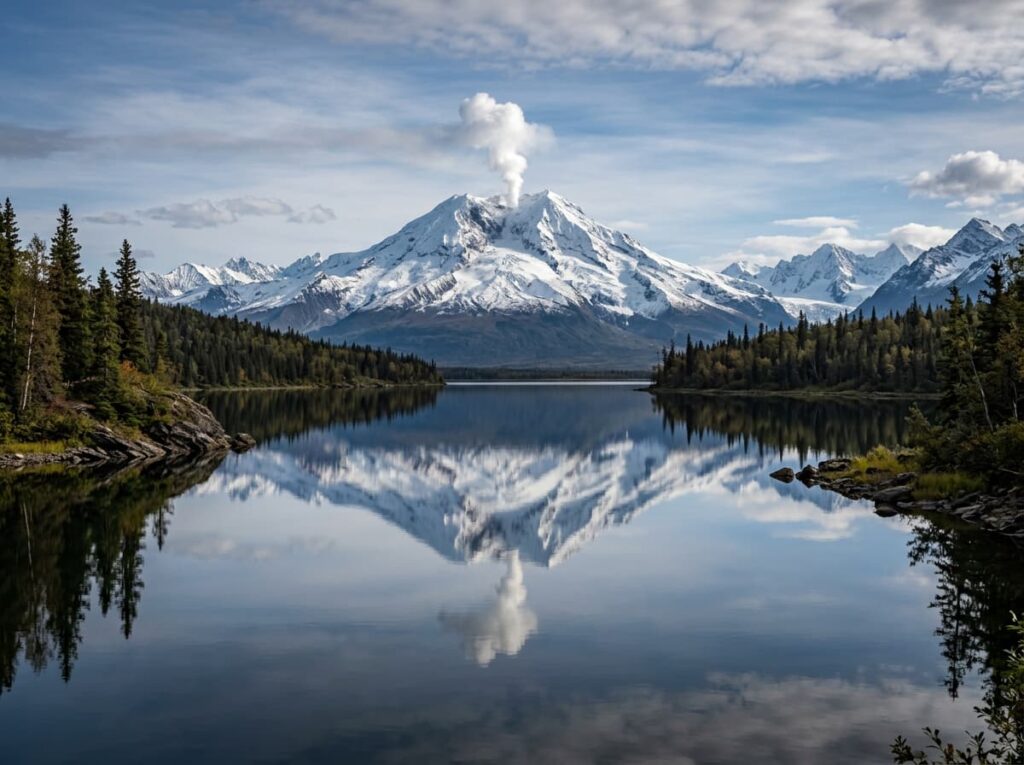
Lake Clark National Park contains four distinct landscape zones that each constitute a major photography destination in their own right. The Chigmit Mountains along the park’s eastern boundary form the spine of the Alaska Peninsula where the Alaska Range and the Aleutian Range converge — a wall of glaciated peaks including Mount Redoubt and Mount Iliamna, both active stratovolcanoes, that rise above Cook Inlet in a formation visible from Anchorage on clear days. The interior river systems drain the mountain flanks through braided gravel channels and boreal forest valleys. The freshwater lake system, centered on Lake Clark itself, provides the float plane access and the clear water fishing that the park is known to pilots and anglers throughout Alaska. And the Cook Inlet coastline at the park’s western edge is the tidal flat and estuary environment where the brown bear photography concentrates.
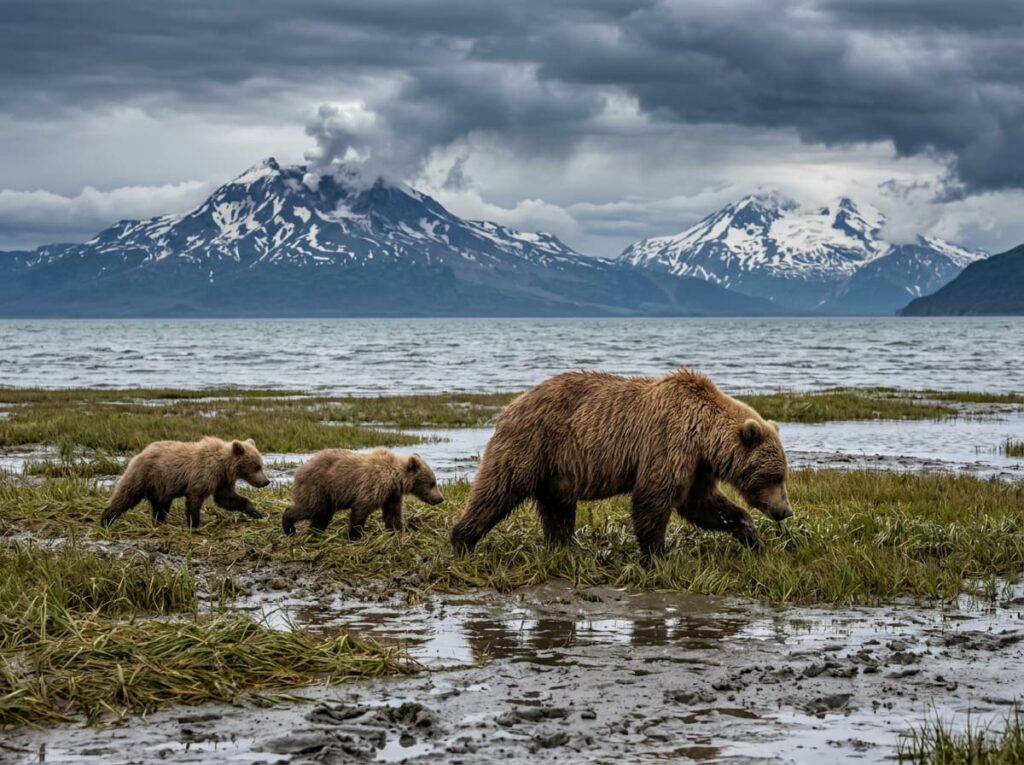
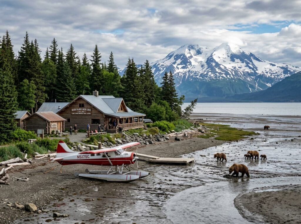
The brown bears of Lake Clark’s coastline are the wildlife subject that has made the park increasingly known among serious wildlife photographers. The tidal flats along Chinitna Bay and Crescent Lake on the Cook Inlet coast support brown bear concentrations that rival Katmai in density during the summer sedge grass feeding season and the clam digging season in fall. The difference from Katmai is the absence of the managed platform system — at Lake Clark the bears are in a truly wild context, with no viewing infrastructure between the photographer and the animal except the distance and the understanding that the bear has the right of way.
The Telaquana Plateau in the park’s interior is the alpine photography zone — a high tundra plateau above the tree line with mountain views in every direction, wildflower meadows in July, caribou and Dall sheep on the ridgelines, and the solitude of a landscape that very few people ever reach. Access requires a floatplane to a remote airstrip or lake, followed by backpacking on unmarked routes through a roadless wilderness. This is the Gates of the Arctic end of the Lake Clark spectrum, and it is as demanding and as rewarding as that comparison suggests.
The Photographer’s Chase
The coastal bear photography is the primary target for most Lake Clark photographers and the subject that distinguishes the park from the other Alaska parks in this series. The Chinitna Bay area on the Cook Inlet coast is the most accessible bear photography location — a floatplane from Anchorage or Homer reaches the coastal lodges in under an hour, and the bears on the tidal flats are visible from the lodge area and accessible on guided walks with the local bear guides who operate with a deep knowledge of individual bears and their behavioral patterns.
The coastal bear photography at Lake Clark differs from Katmai in setting and in mood. Where Katmai concentrates bears at a specific waterfall in a managed viewing context, Lake Clark presents bears in the full sweep of the Cook Inlet coastal landscape — the tidal flats stretching to the water, Mount Redoubt and Mount Iliamna visible across the inlet on clear days, the bears moving through sedge grass and digging clams at low tide with the volcanic peaks as backdrop. The wide angle bear-in-landscape composition is Lake Clark’s specific contribution to the Alaska bear photography canon.
The volcanic landscape photography from the floatplane approach is the aerial perspective that every Lake Clark visitor receives whether or not they plan for it. The flight from Anchorage or Homer crosses Cook Inlet and approaches the park over the Chigmit Mountains, providing an aerial view of the active volcanoes, the glaciated peaks, and the braided river systems below that no ground-level position can replicate. A camera accessible during the flight — a wide angle for the mountain panoramas, a moderate zoom for the river system patterns below — is the preparation that turns the transit into a productive photography session.
The storm light that the Cook Inlet weather system produces is the atmospheric photography condition that the park’s title references and that Alaska coastal parks deliver with regularity. The weather rolling off Cook Inlet across the tidal flats, the dark clouds above the volcanic peaks, and the bears moving through the tidal grass with the storm building behind them — that combination of wildlife and weather in a genuinely wild coastal setting is the image that the managed parks of the lower 48 cannot produce. Being at Lake Clark when the weather moves through requires accepting the unpredictability of Alaska coastal conditions and treating the storm as the subject rather than the obstacle.
Getting There — The Floatplane Is the Road
There are no roads connecting Lake Clark National Park to anywhere. All access is by small aircraft — floatplanes landing on lakes or wheels-planes landing on gravel airstrips — or by boat along the Cook Inlet coast from Homer or Kenai. The floatplane is the practical access for most visitors, and the primary departure points are Anchorage and Homer.
From Anchorage, the flight to the coastal lodges near Chinitna Bay takes approximately 45 minutes in a floatplane — crossing Cook Inlet and arriving at the tidal flat environment that is the park’s primary wildlife photography zone. From Homer on the Kenai Peninsula, the crossing is shorter and the Homer Spit provides the staging point for both floatplane and boat access to the park’s southern coastal areas. Several air taxi operators in both Anchorage and Homer specifically serve Lake Clark, and booking through an operator familiar with the park’s seasonal bear activity patterns provides the most productive timing guidance.
The Port Alsworth community on the shore of Lake Clark itself is the only permanent settlement inside the park — a small community of year-round residents that includes the park headquarters and the Farm Lodge, the primary accommodation option for interior lake visits. Port Alsworth is reached by small aircraft from Anchorage and provides the base for lake fishing, kayaking, and backcountry access into the park’s interior mountain zones.
Where to Stay
The coastal bear viewing lodges near Chinitna Bay and Silver Salmon Creek are the primary accommodation for photographers targeting the tidal flat bear photography. Silver Salmon Creek Lodge and Redoubt Mountain Lodge are the most established operations — small, fly-in wilderness lodges with guided bear viewing, comfortable accommodations for the Alaska wilderness context, and the local knowledge about individual bear behavior that independent visitors cannot replicate. Both lodges book out well in advance for peak July and August season, and the all-inclusive structure covers flights from Homer, meals, lodging, and guided bear viewing.
The Farm Lodge in Port Alsworth provides the interior lake experience — a family-operated lodge on Lake Clark with access to the mountain and river zones of the park’s interior. For visitors who want the full Lake Clark spectrum rather than the coastal bear focus, Port Alsworth is the base that allows both the coastal flight and the interior wilderness access from a single location.
There is no RV access to Lake Clark under any circumstances. No road connects the park to the highway system and no vehicle ferry serves the coastline. This is the fourth fly-in Alaska park in this series, and the same principle applies — the gear that matters is what fits in a small aircraft. The camera bag gets refined down to what is genuinely essential when the alternative is leaving it on the Anchorage tarmac.
If I Were Planning My First Visit
The coastal lodge approach for the first visit — Silver Salmon Creek or Redoubt Mountain Lodge, booked well in advance for late July or August when the bears are most active on the tidal flats and the volcanic peaks are most likely to be visible across the inlet.
Three nights at the coastal lodge minimum. The bear photography requires multiple sessions at the tidal flats across different tide cycles and different light conditions — the low tide morning sessions when the bears are digging clams, the afternoon sedge grass feeding, and the evening light on the flats with the volcanic peaks behind. No single session covers everything. The lodge guides know which bears are where and when, and that knowledge is worth the all-inclusive price.
The camera accessible on the floatplane in and out — the aerial views of the Chigmit Mountains on approach and departure are the mountain photography that the coastal stay cannot provide from ground level. The floatplane window seat on a clear day above the Alaska Range is a photography session in itself.
And the storm. When the Cook Inlet weather builds and the clouds drop over the inlet and the bears keep moving through the sedge grass with the dark sky above them and the volcanic peaks disappearing into the overcast — that is the Lake Clark image. Not the postcard version with the clear sky and the reflections. The real version, with the weather that Alaska produces and the bears that do not notice it.
The Light I’m Curious About
It is the storm light on the Cook Inlet tidal flats — the specific quality of overcast Alaska coastal light when the weather system rolling off the inlet drops the sky to the mountain tops and the bears on the tidal flats are illuminated by the diffused gray light that Alaska produces with regularity and that wildlife photographers have learned to value over the clear-sky postcard conditions.
The overcast light that Katmai delivers is good for bear photography because it eliminates the contrast between dark fur and bright water. The overcast light at Lake Clark does the same thing and adds the drama of the weather system behind the bears — the dark clouds above the tidal flats, the volcanic peaks disappearing into the overcast, and the bears moving through the sedge grass with complete indifference to the conditions above them.
That is the Alaska light that this series has been building toward across five parks and four thousand miles of wilderness. Not the dramatic golden hour that the temperate parks are built around. The gray, overcast, weather-driven light of a landscape that operates on its own terms and does not arrange itself for the photographer’s convenience. That indifference is the invitation. Lake Clark is the destination.
A Deeper Exploration
This article is part of my ongoing project documenting and photographing all 63 national parks across the United States.
Along the way, I am creating deeper guides that explore photography locations, travel planning, seasonal light conditions, and personal reflections from the road. Lake Clark is the fifth Alaska park in this series and the one that most completely summarizes what the state offers — the volcanoes, the glaciers, the rivers, the coastline, the bears, and the absence of any road connecting it to the world outside. The floatplane is the road. The weather is the light. The bears are the subject.
Because the most complete wilderness in the national park system contains everything Alaska does in one place, receives 20,000 visitors a year, and is an hour’s floatplane flight from Anchorage. The wilderness is not far. The commitment to reach it is the distance.
One more thing — just between us.
Lake Clark’s remoteness means that most visitors experience only the coastal lodge zone or the Port Alsworth interior. Here are three ways to go deeper into what the park and the surrounding region offer.
Homer, Alaska — the departure point for the southern coastal approach — deserves more than a staging stop. The Homer Spit on Kachemak Bay is one of the most photographically productive small harbors in Alaska, with the Kenai Mountains visible across the bay, halibut fishing boats coming and going, and the specific Alaska coastal town character that Anchorage cannot provide. An evening in Homer before the morning floatplane to Lake Clark is time well spent with a camera.
For the volcanic context that the park’s two active volcanoes provide, the Alaska Volcano Observatory website monitors Mount Redoubt and Mount Iliamna in real time — the same resource that Hawai’i Volcanoes photographers check before visiting Kilauea. Knowing the current volcanic activity status before the Lake Clark flight adds the geological awareness that the landscape deserves.
And for the complete Cook Inlet bear and coastal experience that extends beyond Lake Clark, the Kenai Fjords boat tour from Seward completes the Alaska coastal arc that this series began — the spontaneous boat ticket that became the highlight of the 50 at 60 journey, revisited with the full context of everything the Alaska parks have delivered since. The same coastline, seen again with different eyes.