A Photographer’s First Look at Maui’s Summit Volcano — and the Sunrise That Requires a Permit, a 3am Alarm, and a Drive Above the Clouds
Some landscapes exist in two completely separate registers and the transition between them is part of the experience. Haleakala National Park on Maui begins at sea level in the tropical warmth that defines the Hawaiian imagination — the ukulele and the plumeria and the particular quality of Pacific island air that is warm and salt-tinged and deeply specific to this archipelago. And then the road climbs. Past the pineapple fields and the upcountry ranches, through the cloud layer at 7,000 feet, above the clouds into the alpine zone at 9,000 feet, and finally to the summit of Haleakala at 10,023 feet — a dormant shield volcano whose summit crater is 2.5 miles wide and 2,100 feet deep and looks, on a clear morning above the cloud layer, like the surface of another planet.
I have been to Hawaii multiple times — the honeymoon, the family trip with my daughter, and the final state of the 50 at 60 journey, all of them on Oahu. The Big Island visit for Hawai’i Volcanoes is already in the planning for this project. Haleakala is the Maui chapter that the Oahu visits never reached, and the research I have done in preparation has made it clear that this is one of the more specifically rewarding sunrise photography experiences available in the national park system — if you have the permit.
The sunrise permit is the first planning decision and it governs everything else. The NPS limits vehicles at the Haleakala summit during sunrise due to the extreme popularity of the experience and the limited parking. Reservations are required for all vehicles entering the summit area between 3am and 7am, available through recreation.gov starting 60 days in advance at 7am Hawaii Standard Time. They sell out within minutes of the booking window opening. Building the Maui trip dates around permit availability — rather than the other way around — is the only strategy that works.
The Landscape That Draws People Here
Haleakala National Park covers 33,265 acres of the eastern Maui volcano, from the summit crater at 10,023 feet to the Kipahulu coastal district on Maui’s southeastern shore. The two sections of the park are not connected by road through the park — the summit district and the Kipahulu district require separate drives via the Hana Highway, making them functionally two different park experiences within the same unit.
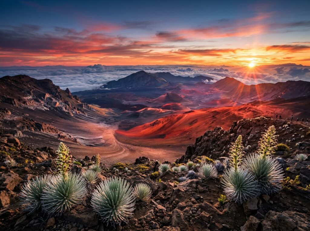
The summit crater is the landscape that defines the park’s visual identity. Haleakala means House of the Sun in Hawaiian, and the name reflects the scale of the summit feature — a crater large enough to contain the entire island of Manhattan, formed by volcanic activity and subsequently carved by erosion into the dramatic cinder cone landscape visible from the rim overlooks. The cinder cones within the crater floor, colored red and orange and black by different mineral compositions, produce a surface that looks geologically alien in the morning light above the cloud layer.
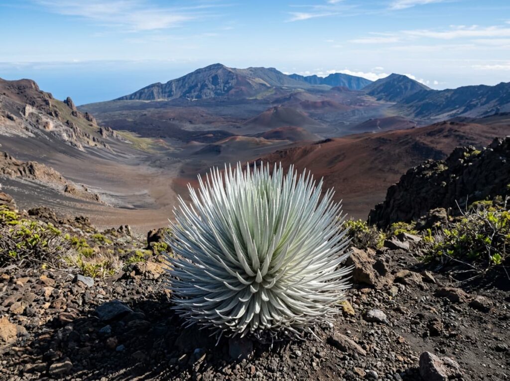
The silversword is the park’s most botanically significant endemic plant — a relative of the sunflower that grows only on Haleakala’s volcanic slopes between 6,500 and 10,000 feet, takes 15 to 50 years to bloom, produces a single spectacular flower stalk, and then dies. The silversword’s silver-gray leaves are adapted to reflect the intense solar radiation at altitude and to collect moisture from the passing clouds. Photographed close with the crater in the background, the silversword is as specifically Haleakala as the saguaro is specifically Sonoran Desert.
The Kipahulu district on the coast is the waterfall and rainforest counterpart to the summit’s volcanic landscape. The Oheo Gulch area, where a series of freshwater pools cascades toward the ocean through a lush Hawaiian rainforest, is the most visited part of the coastal district. The Pipiwai Trail climbs from the pools through bamboo forest and native Hawaiian rainforest to Waimoku Falls, a 400-foot cascade that falls from the volcanic cliff face into a pool at the trail’s end. The contrast between the summit’s volcanic moonscape and the coastal district’s tropical waterfall landscape is the full range of what a Hawaiian volcano park contains.
The Photographer’s Chase
The sunrise from the summit is the primary photography target and the logistics are specific and non-negotiable. The permit covers the vehicle entry window between 3am and 7am. The drive from the Maui lowlands to the summit takes approximately 1.5 to 2 hours depending on starting point, which means departing before 3am for the earliest entry positions. The summit is cold — temperatures at 10,000 feet in the pre-dawn hours regularly drop below 40 degrees Fahrenheit and the wind chill can be significant. Layers, a jacket, and gloves are not optional. The same photographer who arrived in Maui in shorts and sandals needs a winter layer for the summit at 4am.
The Pu’u’ula’ula Summit overlook at the highest point provides the most elevated perspective on the crater and the cloud sea below. The Pa Ka’oao White Hill area provides a slightly lower position with the crater visible in one direction and the island of Maui spreading below in the other. Both positions reward arriving early — 45 minutes before sunrise to allow time to find the composition, set up the tripod, and let the eyes adjust to the pre-dawn darkness before the color sequence begins.
The color sequence at Haleakala sunrise is the photography event. The sky above the cloud layer begins to lighten from the east, the cloud sea below the summit picking up the first color before the sun crests the horizon. As the sun rises, the light hits the cinder cone crater floor in reds and golds that the overhead midday sun completely eliminates. The silversword plants on the crater rim, lit from the side by the first direct sun, are the intimate foreground that anchors the wide crater compositions. The entire productive window from first color to direct sun lasts perhaps 45 minutes. Then the light rises and the drama reduces and the day visitors with their tour bus tickets begin arriving.
The Sliding Sands Trail descends from the summit into the crater floor — the only way to be inside the volcanic landscape rather than looking down at it from the rim. The full crater crossing is a strenuous multi-day backpacking route, but the first mile or two of the Sliding Sands Trail provides accessible crater floor photography in the morning light. The cinder cone textures, the silversword plants at close range, and the crater walls rising above on all sides are the intimate volcanic landscape photographs that the rim overlooks cannot provide.
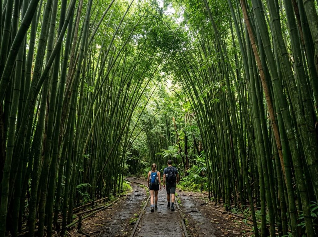
The Kipahulu Pipiwai Trail photography is the full-day extension of the summit visit. The bamboo forest section of the trail, where the dense bamboo creates a green tunnel above the path, is the most specifically photogenic section — the light filtering through the bamboo canopy, the sound of the stalks in the wind, and the sudden emergence from the bamboo onto the viewpoint above Waimoku Falls. The falls in the late morning light, before the afternoon clouds build over the mountains, is the Kipahulu photograph.
The Sunrise Permit — This Comes First
The Haleakala sunrise reservation is the most competitive permit in this project after the Brooks Falls viewing platform at Katmai. Reservations open on recreation.gov 60 days in advance at 7am Hawaii Standard Time — note that Hawaii does not observe daylight saving time, so the mainland equivalent time shifts seasonally. The permits cover a specific entry window and sell out within minutes on most days.
The strategy is identical to every competitive permit in this series. Set a calendar reminder 60 days before the target date. Be at the computer or phone at 7am Hawaii time with the payment information ready and the vehicle and party size confirmed. Have backup dates identified in case the primary date is unavailable. The permit is the trip. Everything else is logistics built around it.
Visitors staying at the Haleakala Campground or Hosmer Grove Campground inside the park do not need a sunrise permit — the permit covers the vehicle entry window for day visitors. Camping inside the park provides sunrise access without the permit competition, though the campground itself fills well in advance through recreation.gov. Cabins inside the crater are available by reservation for multi-day backpackers.
Where to Stay
There is no hotel lodging inside Haleakala National Park. The Maui upcountry communities of Kula and Makawao, on the volcano’s western slopes between 2,000 and 4,000 feet, provide the closest outside lodging and the most convenient starting point for the pre-dawn summit drive. Staying at elevation in Kula reduces the summit drive to under an hour and means arriving in the cold without the full two-hour predawn drive from the beach resorts.
The Kula Lodge is the most established upcountry accommodation — a small lodge property at 3,200 feet with crater views and a restaurant that is the natural breakfast stop after the summit descent. The upcountry Maui vacation rental market has numerous options in Kula and Makawao that provide kitchen access and the slower pace of the upcountry community as a counterpoint to the resort experience of the coast.
For the Kipahulu coastal district visit, the Hana area provides the base — the Hotel Hana-Maui is the iconic property, a low-key luxury resort in the small community at the end of the Hana Highway. The drive to Kipahulu from Hana is about 10 miles further along the coast. Combining a Hana stay with the Kipahulu waterfall visit makes the most of the remote southeastern Maui experience. There is no RV access to Haleakala that accommodates large vehicles — the summit road is narrow and steep and the Hana Highway is famous for its one-lane bridges and tight turns.
If I Were Planning My First Visit
The permit secured 60 days in advance before any other planning begins. A upcountry Maui base in Kula for the summit visit — the shorter predawn drive, the upcountry atmosphere, and the natural breakfast stop at the Kula Lodge on the way back down.
The summit at 4am on permit day — layers on, tripod in hand, in position at the Pu’u’ula’ula overlook before the first color appears in the east. The 45-minute color window fully committed — shooting the cloud sea as it lights up below, the cinder cone crater going from shadow to red-gold, the silversword plants in the side light at the crater rim. Staying at the overlook until the light rises and the tour buses arrive and the window closes.
The first mile of the Sliding Sands Trail after the sun rises — descending into the crater while the morning light is still low enough to be interesting, the cinder textures and the silversword close-range photography that the rim cannot provide. Then back up and back down the mountain to a late breakfast and the warm Maui lowlands that feel like a different planet from the summit an hour above.
And the Kipahulu district on a separate day — the Hana Highway drive, the bamboo forest, Waimoku Falls in the morning light. The full Haleakala story from summit to sea. Hawaii has given me a honeymoon, a family memory, and a completed journey on Oahu. Maui gives the photography that the island was holding in reserve.
The Light I’m Curious About
It is the first color on the cloud sea below the summit — the specific moment before the sun crests the horizon when the cloud layer below the summit begins to catch the light from the east and the white cloud surface turns pink and then gold while the crater above is still in the pre-dawn blue.
Standing above the clouds at 10,000 feet on a Hawaiian volcano and watching the cloud layer below turn color before the sun arrives is a photography experience that requires the permit and the 3am alarm and the cold and all of the planning that this park demands. The light that produces it is available every clear morning from the Haleakala summit. It has been available every morning since the volcano formed.
The ukulele is still there in the lowlands below the cloud layer. The warm air is still there. The plumeria is still there. Haleakala holds all of it — the tropical and the volcanic, the sea level and the summit, the ukulele and the 10,000-foot silence above the clouds. The light connects them. The permit is the price of admission to see how.
A Deeper Exploration
This article is part of my ongoing project documenting and photographing all 63 national parks across the United States.
Along the way, I am creating deeper guides that explore photography locations, travel planning, seasonal light conditions, and personal reflections from the road. Haleakala is the second Hawaiian national park in this series after Hawai’i Volcanoes — the dormant summit counterpart to the active caldera, the above-cloud sunrise counterpart to the lava lake night, the Maui chapter of the Hawaii story that Oahu and the Big Island have been building toward.
Because the House of the Sun is 10,023 feet above the Pacific Ocean on a tropical island, and the sunrise from its summit is one of the more specifically extraordinary photography experiences available in the national park system. The permit is competitive. The alarm is early. The summit is cold. The light is worth every bit of all three.
One more thing — just between us.
Haleakala’s sunrise draws the permitted crowd to the summit overlooks — the right call for the sunrise photography, but the park has more to offer when the day visitors clear. Here are three places worth knowing.
The Hosmer Grove area just inside the park entrance at 6,800 feet is where the rare native Hawaiian birds concentrate — the nene goose, the Maui alauahio, and the iiwi are all present in the native forest that the grove protects. The bird photography here is among the finest endemic Hawaiian species photography accessible without a backcountry permit, and the morning light in the native forest is a subject the summit overlooks never show.
For the Maui photography that extends beyond the park, the drive to Hana on the Road to Hana is one of the great scenic drives in the Hawaiian Islands — 52 miles of coastal road with more than 50 one-lane bridges, waterfalls visible from the road, and the lush windward Maui character that the resort side of the island cannot offer. The drive itself is the photography and the destination.
And for the sunrise experience without the permit competition, the Polipoli Spring State Recreation Area on Haleakala’s western slope at 6,200 feet produces cloud inversion photography — the upcountry above the cloud layer, the West Maui Mountains visible across the cloud sea — that the summit overlooks offer at a much higher elevation and with much more competition for parking. Polipoli at dawn is the photographers’ secret that most Maui visitors never find.