A Photographer’s Return to Ohio’s Unexpected National Park — Beyond the Waterfall at the End of the Boardwalk
Some landscapes become part of our imagination long before we ever visit them. Cuyahoga Valley National Park is not one of those. Most people discover it the way I did — by remembering, somewhere in Ohio, that a national park exists somewhere nearby and deciding to find out where.
I was driving between a family visit in western Pennsylvania and another in Michigan, and somewhere on the route the thought surfaced: there’s a national park in Ohio, isn’t there? I took the detour. I found the park. I walked the boardwalk to Brandywine Falls, photographed the waterfall, and got back in the car and continued north. It was a pleasant stop. The falls are genuinely beautiful. And I saw approximately five percent of what Cuyahoga Valley National Park actually is.
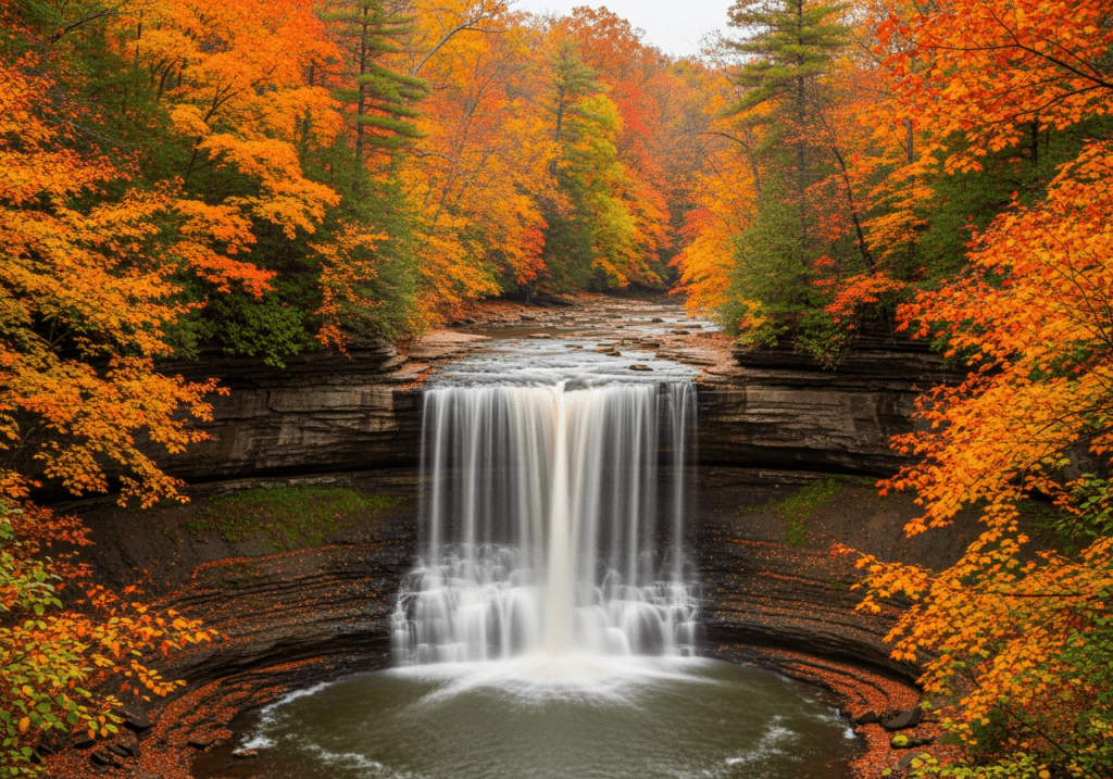
Brandywine Falls is the park’s most photographed subject and its most obvious first stop — a 65-foot cascade over layered shale and sandstone, accessible via a short boardwalk, visible from a viewing platform that puts the falls in a clean compositional frame. It is the postcard of the park and it earns that status. But it is also the place that most casual visitors see and mistake for a summary of the park rather than an introduction to it.
Cuyahoga Valley is 33,000 acres of forested river valley between Cleveland and Akron — a landscape shaped by the Cuyahoga River, glacial geology, 19th-century canal history, and the kind of dense hardwood forest that the Midwest produces when it has been left largely alone for long enough. It is a park that rewards the visitor who slows down and looks carefully at a landscape that does not announce its beauty dramatically but reveals it in layers. I did not slow down. The return trip is about finding out what those layers are.
The Landscape That Draws People Here
Cuyahoga Valley occupies the river valley carved by the Cuyahoga River between two of Ohio’s largest cities — a 22-mile stretch of protected land that serves as the green corridor between Cleveland and Akron and draws more than two million visitors annually, many of whom are local residents treating it as a regional park rather than a national destination. That local familiarity is part of what makes the park underestimated by visitors passing through: if the people who live next to it treat it as a pleasant day trip rather than a serious destination, it is easy to absorb that assessment without questioning it.
The Ohio and Erie Canal Towpath Trail runs 87 miles through the park along the route of the historic canal that connected the Ohio River to Lake Erie in the 1820s and 1830s. The towpath is the park’s spine — a flat, accessible trail through the river valley that passes canal locks, historic canal-era structures, beaver marshes, and the river itself. Cycling the towpath is one of the park’s primary activities, and the trail photography along it — the canal locks, the herons in the marshes, the river in fall color — is the intimate historical landscape photography that makes this park distinctive among the eastern parks.
The Cuyahoga River itself is the park’s defining natural feature and a remarkable ecological recovery story — the river that famously caught fire in 1969, so polluted that its surface was ignitable, is now a healthy waterway supporting fish populations, beavers, river otters, great blue herons, and the bald eagles that have returned to nest along its banks. Photographing a bald eagle on the Cuyahoga River in a national park in Ohio is not the obvious wildlife photography story. It is the real one.

The Photographer’s Chase
Brandywine Falls is the right starting point and I do not regret the boardwalk photograph. But it is a starting point, not a summary. The falls in the right light — early morning in October when the fall color frames the cascade, or after a rain when the flow is at its peak and the mist fills the gorge — are a genuinely strong waterfall photography subject. An overcast morning eliminates the harsh contrast between the bright water and the dark shale walls and saturates the surrounding vegetation to its full autumn color. The boardwalk puts you at a fixed viewpoint; the trail descending below the falls to the creek level puts you at a completely different one.
The Towpath Trail in October is the photography subject I most want to return for. The 87-mile trail through the river valley passes through hardwood forest in peak fall color, along beaver marshes where the standing dead trees and the still water create the reflection photography that the moving river cannot, and past the historic canal lock structures — stone masonry from the 1820s, moss-covered and precise, the evidence of an era when this valley was the commercial corridor of the Ohio frontier. A morning on the towpath in October, moving slowly on foot or by bicycle, is the intimate historical landscape photography that the waterfall boardwalk cannot offer.
The beaver marshes along the Towpath are the wildlife photography target that most visitors miss. The wetlands created by beaver activity support great blue heron colonies, great egrets, wood ducks, and the bald eagles that hunt the river corridor. Dawn at the marsh edge, before the trail becomes active with cyclists and hikers, is when the wading birds are most active and most approachable. A 400mm lens from the trail bank, in the first light of an October morning, on a great blue heron standing in the still water of a beaver marsh with the fall color behind it — that is the Cuyahoga Valley photograph that does not appear on any postcard.
The Scenic Railroad — the historic train that runs through the valley between Independence and Akron — is both a visitor experience and a photography subject. The vintage passenger cars moving through the fall color of the river valley, with the Cuyahoga River visible through the trees, is the kind of transportation-in-landscape image that requires being in the right position at the right moment. The railroad schedule is publicly available; positioning along the tracks in the fall color with a telephoto and a known train time is straightforward photography planning that produces a specifically and historically Cuyahoga Valley image.
Visiting the Park
Cuyahoga Valley is open year-round and free to enter — no entry fee, no timed reservations, no permit requirements for standard day use. That accessibility, combined with its location between two major cities, makes it one of the most visited parks in the system by raw numbers — but the visitation is spread across 33,000 acres of trail system in a way that makes the park feel uncrowded away from the Brandywine Falls boardwalk and the most popular trailheads.
Fall is the primary photography season — the hardwood forest peaks in mid-October and the light in the river valley on a clear fall morning, low and warm and filtered through the color canopy above the Towpath, is the best the park produces. Spring brings wildflowers along the forest trails and the highest water flow for the waterfall photography. Winter is underrated — the frozen Brandywine Falls, ice formations on the shale walls, snow on the canal locks, and the complete absence of crowds produce a dramatically different and equally photogenic park that almost no one visits intentionally.
The Cuyahoga Valley Scenic Railroad operates seasonally and the schedule varies; check cvsr.com for current departure times and routes. The park’s visitor centers at Canal Exploration Center and Happy Days Lodge provide orientation and current trail condition information. The Boston Mill Visitor Center is the most centrally located for Brandywine Falls access.
Where to Stay
There is no in-park lodging at Cuyahoga Valley. The Inn at Brandywine Falls, a historic bed and breakfast in a 19th-century Greek revival home immediately adjacent to the falls, is the closest lodging to the park’s primary photography subject and one of the more distinctive accommodation options in the national park system — staying within walking distance of Brandywine Falls means being at the cascade before the day visitors arrive, in the morning mist and the early light that the midday boardwalk crowd never experiences.
The surrounding communities of Peninsula, Hudson, and Brecksville provide additional independent lodging options within easy reach of the park’s major access points. Peninsula, a small historic village in the center of the park, has the most character — a 19th-century Main Street within walking distance of the Towpath Trail and the Cuyahoga River. Staying in Peninsula and spending a morning on the Towpath before the trail fills with cyclists is the most immersive base camp option the area offers.
There is no traditional campground inside the park, but the Stanford Hostel — a historic farmhouse converted to hostel use inside the park boundary — provides the most affordable in-park overnight option. For RV travelers, private campgrounds in the surrounding communities offer full hookup options within a short drive of the main park access points.
If I Were Planning My First Visit
The detour between family visits was not nothing — it found the waterfall, it confirmed the park existed, it planted the question of what else was there. The return trip answers that question properly.
October. The Inn at Brandywine Falls or a Peninsula rental, close enough to the Towpath to walk to it before sunrise. Brandywine Falls first — but this time in the early morning light before the boardwalk fills, with a tripod and a long exposure and the fall color framing the cascade. Then the Towpath, moving slowly south along the river, watching the beaver marshes for the herons and the eagles. The canal locks at mid-morning when the light finds the moss-covered stone. The river in the afternoon when the fall color catches the low western sun.
And the railroad. A morning spent with the train schedule and a telephoto, positioned in the fall color along the line, waiting for the vintage cars to come through the valley. That is the image that tells the full story of this place — the river that recovered, the forest that grew back, the valley that became a national park between two cities that needed it more than they knew.

The Light I’m Curious About
It is the Towpath light in October at dawn.
The canal towpath in the early morning, before the cyclists arrive, when the river is still and the fall color is overhead and the light is just finding its way through the canopy to the water — that is the light that the detour-between-family-visits version of this park does not show you. The Cuyahoga River reflecting the October color above it, a great blue heron standing motionless at the bank, the stone canal locks in the middle distance, the valley quiet in the way that only early morning in a forest can be quiet.
This is not the most dramatic national park in the system. It does not have the geological spectacle of the canyon parks or the alpine scale of the mountain parks. What it has is a river that came back from the dead, a forest that grew back around it, and a valley that two million people a year use as a reminder that wildness does not have to be remote to be real. That story deserves better photography than a waterfall at the end of a boardwalk on a drive between family visits.
The return trip will give it that.
A Deeper Exploration
This article is part of my ongoing project documenting and photographing all 63 national parks across the United States.
Along the way, I’m creating deeper guides that explore photography locations, travel planning, seasonal light conditions, and personal reflections from the road. Cuyahoga Valley is the park that taught me the most important thing about proximity: the parks closest to population centers are often the ones most taken for granted, by locals and visitors alike. The ones worth returning to with a camera and a slower pace.
Because sometimes the national park between two cities in Ohio has more to show you than the waterfall at the end of the boardwalk. You just have to come back and find out.
One more thing — just between us.
Cuyahoga Valley is already quieter than most national parks, but the Brandywine Falls boardwalk and the main Towpath access points draw the bulk of the visitors. Here are three places in and around the park worth finding when you want to slow down even further.
Virginia Kendall Ledges — a section of the park near Peninsula that most visitors skip in favor of the waterfall — has exposed sandstone ledges, hidden rock shelters, and a forest trail system with a completely different geological character from the river valley. The light on the sandstone formations in the late afternoon, filtered through the hardwood canopy, is one of the park’s most distinctive and least photographed subjects.
Just outside the park, Tinkers Creek Gorge is a National Natural Landmark within the park’s boundaries where the creek has carved a 190-foot deep gorge through the surrounding plateau — old-growth hemlocks, dramatic cliff faces, and almost no foot traffic relative to the main Towpath corridor.
And for a completely different Ohio experience nearby, the village of Peninsula sits right in the middle of the park — a genuine 19th-century canal town with independent shops, the Towpath running through it, and the Cuyahoga River visible from Main Street. Walking the village at dusk when the day visitors have left is the kind of quiet, human-scale photography that the parks-as-landscape narrative never quite captures.