A Photographer’s First Look at the Largest National Park in the United States — a Place Bigger Than Switzerland That Almost Nobody Has Heard Of
Every photographer eventually builds a list of places they cannot believe exist at the scale described. Wrangell-St. Elias National Park and Preserve is at the top of that list. It covers 13.2 million acres of southeastern Alaska — larger than the entire country of Switzerland, larger than Yellowstone and Yosemite and the entire Swiss Alps combined. It contains nine of the sixteen highest peaks in the United States. It holds the largest collection of glaciers outside the polar ice caps. The Bagley Icefield alone, one of several major ice systems within the park, covers more area than the state of Rhode Island.
The park receives approximately 80,000 visitors per year. On a busy weekend at Yellowstone, that many people arrive before noon.
I had not heard of Wrangell-St. Elias before this project. That admission is worth making plainly because it applies to most Americans, including most people who consider themselves knowledgeable about the national park system. The park exists at a scale that resists the imagination and in a location — southeastern Alaska, bordering Canada’s Kluane National Park in a combined UNESCO World Heritage Site that together constitutes the largest protected wilderness on earth — that most travel itineraries never reach. The numbers are not exaggerations. They are simply what this place is.
Understanding what Wrangell-St. Elias actually offers a photographer requires accepting that it cannot be done in a day or a weekend or even a week. It is a landscape measured in the kind of scale that requires choosing one part of it and going there with full attention, while knowing that what you are not seeing is many times larger than what you are.
The Landscape That Draws People Here
Wrangell-St. Elias National Park sits where four mountain ranges converge — the Wrangell Mountains, the St. Elias Mountains, the Alaska Range, and the Chugach Mountains all meet within the park boundary. The result is the most concentrated collection of high peaks in North America. Mount St. Elias at 18,008 feet is the second highest peak in the United States. Mount Wrangell at 14,163 feet is one of the largest active volcanoes in North America. The Nabesna and Root glaciers are among the most accessible large glaciers in Alaska, reachable by a manageable hike from the park’s two road corridors.
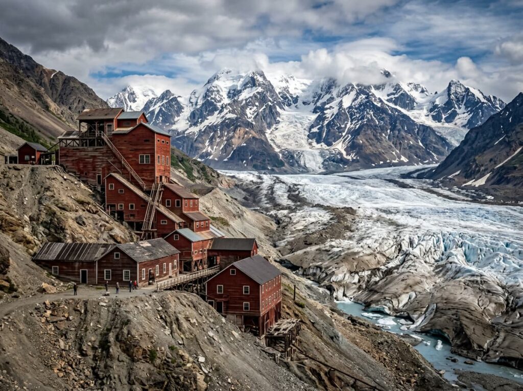
The park has two road corridors that provide the primary visitor access — the Nabesna Road from Slana in the north and the McCarthy Road from Chitina in the south. Both are gravel, both require a vehicle appropriate for unpaved Alaska conditions, and both lead to genuinely extraordinary landscapes. The McCarthy Road is the primary visitor route, ending at the Kennicott River where a footbridge crosses to the historic town of McCarthy and the National Historic Landmark of Kennecott Mines — a former copper mining complex perched on the lateral moraine of the Kennicott Glacier that is one of the most spectacularly situated historic sites in North America.
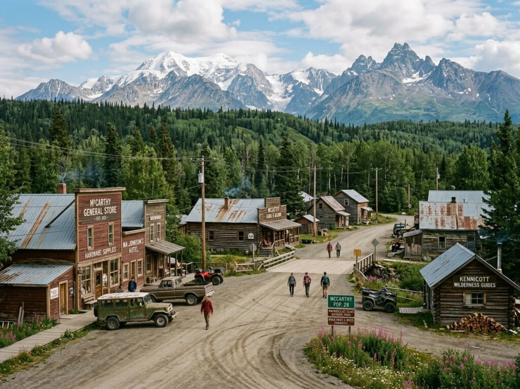
Kennecott is the human history anchor of the park — a complete copper mining town abandoned in 1938 when the copper ore was exhausted, sitting at the edge of a massive glacier with the Wrangell Mountains above and the McCarthy Valley below. The red-painted industrial buildings against the gray glacier and the snow-capped peaks, in the clear light of an Alaska summer day, is one of the most photographically distinctive subjects in the national park system. The combination of industrial heritage and wilderness scale in a single frame is specific to Kennecott and available nowhere else.
The Photographer’s Chase
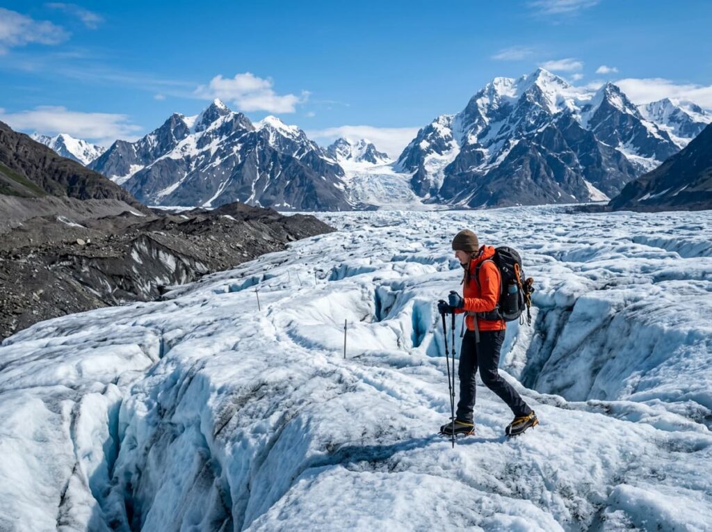
The Kennecott and Root Glacier area is the photography center of the accessible park. The Root Glacier trail from Kennecott — a relatively easy 4-mile round trip — reaches the glacier surface and provides the close-range ice photography that the valley floor cannot. The glacier in the morning light, with the Wrangell Mountains above and the lateral moraine beside it, is the Wrangell-St. Elias composition that communicates the park’s geological scale without requiring a floatplane or a multi-day expedition. Ice crampons are available for rent in McCarthy for those who want to walk on the glacier surface rather than viewing from the edge.
The Kennecott historic buildings are the architectural photography subject that requires the afternoon light from the west to illuminate the red-painted facades fully. The morning light falls on the glacier and the mountains behind the buildings. The afternoon light hits the building fronts directly. Planning the two light windows around the same base at McCarthy or Kennecott allows both the glacier morning photography and the historic building afternoon photography without a vehicle move.
The McCarthy Road drive is itself a photography subject — 60 miles of gravel road through the Chitina River valley with the Wrangell Mountains visible for much of the route. The Chitina River braided channels, the spruce and cottonwood forest of the valley floor, and the progressive revelation of the mountain mass as the road climbs toward McCarthy provide the landscape photography that frames the destination before you arrive. Drive it in both directions at different times of day and treat it as a photography session rather than a transit route.
The backcountry is where the park’s true scale becomes accessible — floatplane access to remote valleys, glacier landings, and river float trips through roadless wilderness. The Chitina and Copper River systems provide multi-day float trip routes through the park’s southern section. The Wrangell Mountains backcountry, accessed by floatplane from McCarthy, provides the alpine tundra and glacier photography that the road-accessible areas cannot. For photographers willing to commit to the logistics, the park’s interior delivers a wilderness photography experience with virtually no other people in it.
Visiting the Park
The primary season runs from late May through September when the McCarthy Road is passable and the McCarthy and Kennecott visitor infrastructure is operating. The McCarthy Road is gravel and requires a vehicle in good condition — a flat tire is common and carrying a spare is not optional. The road is not suitable for low-clearance vehicles and is actively hazardous in wet conditions. Driving it in a rental car requires checking the rental agreement, as many rental companies prohibit gravel road driving in Alaska.
The park has no entrance fee and no timed entry requirements. The Kennecott footbridge across the Kennicott River is the crossing point for vehicle-free access to McCarthy and Kennecott — vehicles are left at the parking area on the road side of the river. A small shuttle operates between the bridge and the town of McCarthy. The Kennecott Mines National Historic Landmark requires a paid tour for interior access to the historic buildings.
The nearest airport with commercial service is Anchorage, about 200 miles west on the Glenn Highway and Richardson Highway. The drive from Anchorage to the McCarthy Road trailhead takes approximately five hours on paved highway plus the 60-mile gravel road. Fairbanks provides an alternative approach from the north. Several air taxi operators in Glennallen and Chitina provide floatplane access to the park’s interior for backcountry trips.
Where to Stay
McCarthy and Kennecott provide the in-park accommodation options — both accessible only by the footbridge or by floatplane. The Kennicott Glacier Lodge, at Kennecott above the glacier, is the most dramatically positioned lodging in the park — a historic-style property with mountain and glacier views and proximity to the Kennecott historic buildings and the Root Glacier trailhead. Ma Johnson’s Hotel in McCarthy is the more affordable and more characterful option, a frontier-era hotel in a town that still has the feel of a remote Alaska community that the road barely reaches.
Camping is available at informal sites throughout the park and at the McCarthy area campgrounds. The park’s philosophy of minimal infrastructure means that established campgrounds are limited but dispersed camping is widely permitted. For RV travelers, the parking area before the Kennicott River footbridge has a campground with basic facilities — the RV stays on the road side while the photography happens on the other side of the bridge.
Glennallen, about 115 miles west on the Richardson Highway, is the nearest town with a full range of services and provides the last reliable fuel and supplies before the McCarthy Road. The Copper River Princess Wilderness Lodge near Copper Center, about 100 miles west, offers the most comfortable outside lodging with Wrangell Mountains views and proximity to the park access corridor.
If I Were Planning My First Visit
Three nights based at Kennecott or McCarthy — enough time to do the Root Glacier walk, the Kennecott historic buildings photography in multiple light conditions, and the McCarthy Road drive in both directions. July for the maximum daylight, the wildflower bloom on the alpine slopes, and the glacier melt ponds that form on the Root Glacier surface in summer and produce the blue ice photography that colder seasons cannot.
The Root Glacier in the early morning — the glacier surface before the day hikers arrive from McCarthy, the ice in the low morning light, the Wrangell Mountains above before the afternoon clouds build. The Kennecott buildings in the afternoon — the red facades in the direct western sun with the glacier visible below and the mountains above. And the McCarthy Road at golden hour on the drive out — the Chitina River valley in the last light, the mountains going from gold to purple behind the cottonwood forest.
The park that nobody has heard of. 13.2 million acres. 80,000 visitors a year. The Kennicott Glacier below the tent and the Wrangell Mountains above it and the McCarthy Road between here and the rest of the world. That is enough to start with. The rest of the 13.2 million acres will keep.
The Light I’m Curious About
It is the morning light on the Kennecott historic buildings above the glacier — specifically the first direct sun reaching the red-painted mill building facades while the Kennicott Glacier below is still in shadow and the Wrangell Mountain peaks above are already in full alpenglow.
The red of the buildings against the gray of the glacier and the white of the peaks above is the color palette that makes Kennecott one of the most compositionally specific photography subjects in the Alaska parks. The historic buildings and the wilderness scale are both necessary elements — neither alone makes the image. The morning light sequence, moving from the mountain peaks down to the building facades and finally to the glacier below, is a thirty-minute progression that requires being in position before it begins.
A park that covers 13.2 million acres has a great deal of light falling on it every morning. The specific light I am going to Kennecott to find falls on a few acres of red buildings above a glacier in southeastern Alaska, in a park that almost nobody has heard of, in the largest protected wilderness on earth. That specificity within that vastness is the Wrangell-St. Elias argument in one image.
A Deeper Exploration
This article is part of my ongoing project documenting and photographing all 63 national parks across the United States.
Along the way, I am creating deeper guides that explore photography locations, travel planning, seasonal light conditions, and personal reflections from the road. Wrangell-St. Elias is the park that this series most needed to make visible — a landscape that most Americans have never heard of, that covers more land than Switzerland, and that holds nine of the sixteen highest peaks in the country along with the largest non-polar glacier system on earth.
Because the largest national park in the United States deserves to be known. 13.2 million acres have been waiting patiently. The McCarthy Road is 60 miles of gravel between here and the beginning of understanding what that number actually means.
One more thing — just between us.
Wrangell-St. Elias is already one of the least visited major national parks in the system. The insider tip here is about the approach corridor and the connections that frame the park in its full regional context.
The Kluane National Park in Yukon, Canada shares the park’s northern and eastern boundaries in a combined UNESCO World Heritage Site that is the largest protected area on earth. The Alaska Highway through Kluane, with the St. Elias Mountains visible from the road, is one of the great mountain drives in North America and a natural extension of the Wrangell-St. Elias visit for those with a vehicle and the time to drive north into the Yukon.
Chitina on the Copper River — the small community at the start of the McCarthy Road — is the staging point for the drive and a photography subject in its own right. The Copper River salmon runs that pass through Chitina in July are one of the most significant salmon migrations in Alaska and produce the traditional dipnet fishing that Alaska Native communities have practiced here for thousands of years.
And for the aerial perspective on the park that the ground-level visit cannot provide, flightseeing tours from Kennicott operate from the McCarthy airstrip and fly above the Bagley Icefield, the Malaspina Glacier, and the St. Elias peaks in conditions that make the 13.2 million acres comprehensible in a way that no ground-level experience can. One hour above this park changes how you understand every photograph you made from the valley floor.