A Photographer’s Return to the Hottest Place on Earth — in the Season It Becomes Something Else Entirely
When planning a visit to America’s national parks, the name alone should tell you something. Death Valley. It is not subtle. It is not trying to manage your expectations. And yet I drove through it in August without fully internalizing what those two words meant — what the name was actually communicating about the specific and serious relationship between this place and the summer sun.
I understand it now. The car’s air conditioning was running at maximum capacity and barely holding the interior temperature at a level that could be called comfortable. Outside the windows, the thermometer was reading somewhere north of 115 degrees. I stopped twice — once at the Mesquite Flat Sand Dunes, once at a rock formation that caught my eye — and both times I was back in the car within a few minutes, not because I had gotten the photograph but because the air outside the car was a physical force, a dry pressing heat that made every second outdoors feel like a negotiation. I drove through Death Valley in August and came away with a handful of sand dune texture shots and a clear understanding of why they named it what they named it.
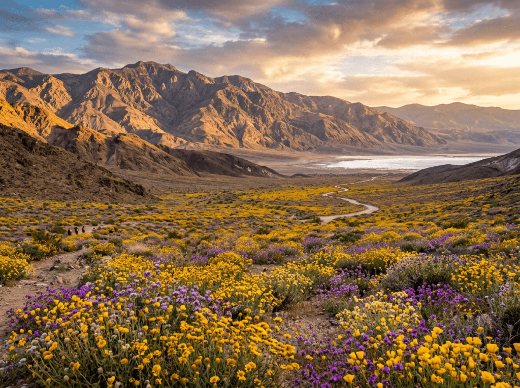
As I write this, my social media feed is full of images from Death Valley that look nothing like the park I drove through. The super bloom is happening — the desert floor covered in wildflowers in colors that seem impossible for a place that receives less than two inches of rain in an average year. Gold and purple and white across the valley floor, the Panamint Mountains behind them, the salt flats of Badwater Basin in the distance. Every image is better than the last one. The most spectacular wildflower display since 2016, by most accounts. And I am not there.
The return trip is about timing. It has always been about timing. I just did not know that on the first visit.
The Landscape That Draws People Here
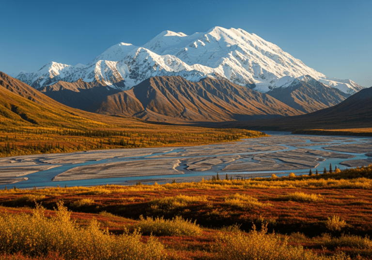
Death Valley National Park is the largest national park in the contiguous United States — 3.4 million acres of the northern Mojave and Great Basin Desert in eastern California and Nevada. It holds the record for the highest reliably recorded air temperature on earth: 134 degrees Fahrenheit, measured at Furnace Creek on July 10, 1913. Badwater Basin, on the valley floor, sits at 282 feet below sea level — the lowest point in North America. The Panamint Range rises to 11,049 feet at Telescope Peak less than 20 miles away. The vertical relief between the valley floor and the mountain summit is greater than the depth of the Grand Canyon.
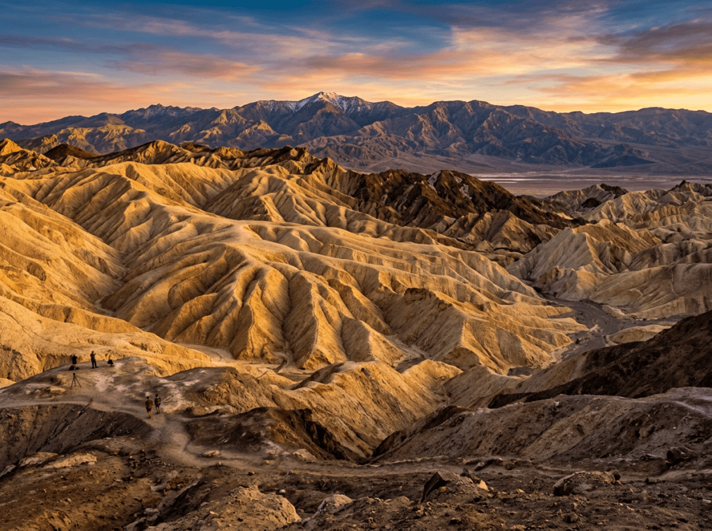
The landscape categories in Death Valley are more varied than the name suggests. The salt flats of Badwater Basin — a vast white expanse of sodium chloride crystals extending across the valley floor — are the most otherworldly of the park’s subjects. The Mesquite Flat Sand Dunes near Stovepipe Wells, the largest dune field in the park, provide the classic desert sand photography that the imagination associates with the Sahara. Artist’s Drive winds through a section of oxidized volcanic hills where the rock faces go through shades of pink, purple, green, and gold in a compressed geological palette that produces abstract compositions unlike anything else in the park system. And the Zabriskie Point badlands — eroded mud hills in a warm golden brown, folded and sculpted by water erosion into forms that look more like something from another planet than California — are the park’s most dramatic overlook subject.
And then there is the super bloom. In years when winter rainfall is significantly above average — typically requiring more than three inches between October and February — the dormant wildflower seeds that have been waiting in the desert soil germinate en masse in late February and March. The valley floor, which is bare and baked for most of its existence, transforms into a carpet of desert gold, desert five-spot, phacelia, and Bigelow’s monkey flower. It does not happen every year. It has not happened in meaningful scale since 2016. When it happens, the images spread across the internet like a rumor that the desert has changed its nature entirely.
The Photographer’s Chase
Death Valley photography requires accepting a fundamental premise: timing is not a secondary consideration. It is the primary one. The same landscape that is actively hostile to human presence in August is genuinely extraordinary in the right season and at the right hour. Getting that right is the entire planning challenge.
The super bloom is the rarest and most spectacular condition — it requires monitoring the winter rainfall totals from November onward and being ready to move when the conditions align. The California Wildflower Hotline and the Death Valley National Park social media accounts are the most reliable sources for current bloom conditions. When the images start appearing in late February, the window for peak bloom photography is typically two to four weeks before the flowers begin to fade. It cannot be scheduled a year in advance. It can only be watched for and responded to quickly when it arrives.
Zabriskie Point at sunrise is the non-super-bloom photography that most consistently rewards the early riser. The badlands east of Furnace Creek catch the first light of the morning in a raking illumination that builds extraordinary shadow and texture into the folded mud hills — warm gold and deep brown in the low sun, the Panamint Mountains visible across the valley behind them. The pre-dawn setup at Zabriskie requires no hiking — the overlook is accessible by car — but the twenty-minute window of raking light before the sun goes overhead is the difference between an extraordinary image and an ordinary one. This is the Death Valley photograph I should have been making instead of driving through in the August midday heat.
The Mesquite Flat Sand Dunes at first light are the other sunrise target — and the texture shots I grabbed jumping out of the air-conditioned car in August were not wrong, just under-lit. The dunes in the first thirty minutes of direct morning sun, with the long shadows of the dune ridges building the three-dimensional form that overhead light destroys, are the sand photography this park is capable of producing. Star dune photography on a moonless night — the Milky Way over the dune field, with the dark Panamint Range silhouette behind — is the night sky version of the same subject, and Death Valley’s extreme darkness makes it one of the premier astrophotography locations in the national park system.
Artist’s Palette along Artist’s Drive is the abstract geology photography that rewards slow driving and close attention — pulling over at the colorful hillside exposures and working the oxidized volcanic rock with a telephoto, finding the abstract color compositions within the larger landscape. The green of the chlorite, the pink and red of the iron oxide, the purple of the manganese — compressed into a hillside that looks painted from a distance and geological up close. This is not a sunrise-only subject. The diffused light of an overcast afternoon, which strips the harsh shadows and reveals the color without blowing out the highlights, is actually the better condition for the Artist’s Palette photography.
Visiting the Park
The seasonal planning at Death Valley is more consequential than at any other park in the system. November through March is the primary photography window — temperatures in the 60s and 70s, the possibility of wildflower bloom in good rain years, and the low-angle winter sun that does the most interesting things to the badlands and the salt flats. April and May are transitional — still manageable temperatures in the early morning but warming quickly, and the bloom, if it happened, beginning to fade. June through September is the extreme heat season, and while the park remains open year-round, the midday temperatures in summer are a genuine safety concern. People die in Death Valley in summer. Carry a minimum of one gallon of water per person per day, tell someone your itinerary, and do not attempt anything beyond air-conditioned vehicle travel during the middle of the day.
For super bloom visits specifically: follow the park’s social media and the California wildflower monitoring sites from November onward in years with above-average winter rainfall. The bloom typically peaks between late February and mid-March in a strong year. Plan to be flexible — the window moves with the weather, and the photographers who chase the bloom successfully are the ones who can move within a few days of the peak being announced rather than those who booked six months in advance.
The park has no timed entry requirements. Cell service is extremely limited inside the valley. Download offline maps before arrival and carry paper backup. The distances between services are greater than they appear on the map, and fuel should be topped off at every opportunity.
Where to Stay
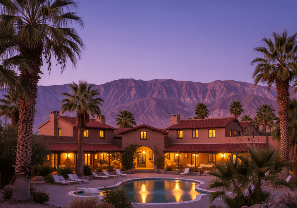
The Oasis at Death Valley — the resort complex at Furnace Creek that includes the historic Inn at Death Valley and the Ranch at Death Valley — is the only in-valley lodging and the obvious base for a photography trip. The Inn, a 1927 adobe building on a rise above the valley floor, has been restored to a standard that justifies its prices — a pool fed by thermal spring water, a dining room with valley views, and a position at the center of the park’s primary photography destinations. Being in the valley at dawn, without an hour’s drive from Pahrump or Baker, makes the Zabriskie Point and salt flat sunrise photography entirely practical.
Stovepipe Wells Village, in the northern section of the valley near the sand dunes, is a more basic in-park option — motel rooms, a campground, and a gas station — that provides the proximity to the Mesquite Flat Dunes for early morning dune photography without the Furnace Creek pricing. For the super bloom photography specifically, knowing in advance which areas of the valley floor are blooming helps determine the better base.
For RV travelers, Furnace Creek Campground is the most centrally located and the most popular — reservable through recreation.gov for the peak season from October through April. Sunset Campground nearby is first-come, first-served. The summer campgrounds are free but the summer heat makes them suitable only for the most heat-adapted travelers. RVs of standard sizes are accommodated throughout the park’s main campgrounds, though the remote dirt roads to some viewpoints have restrictions.
If I Were Planning My First Visit
The first visit has been made. It was August. It was educational in the way that arriving somewhere completely unprepared is always educational — I understand Death Valley’s character now in a visceral way that no amount of reading could have produced. The car thermometer at 115 degrees is a kind of knowledge.
The return trip is November through March, with alerts set for winter rainfall totals from October onward. If the bloom conditions look favorable by January — if the soil moisture readings and the rainfall totals are tracking toward a super bloom year — I want to be there in late February or early March when the valley floor does the thing that drew every photograph currently filling my social media feed. That is the Death Valley I have been watching from a distance. I want to be inside it.
On a non-bloom visit I would be at Zabriskie Point before sunrise on the first morning, at the salt flats of Badwater Basin at golden hour, and at the sand dunes before the wind comes up in the early afternoon. Three subjects, three different light conditions, all within a day’s circuit of Furnace Creek. The park I drove through in August barely resembles the park those three subjects exist in. Same coordinates, completely different place.
The Light I’m Curious About
It is the super bloom light on the valley floor.
The images on my feed right now show something that does not look like a desert. They show a valley covered in gold and purple to the horizon, the Panamint Range behind it, the light of a March afternoon on flowers that have been waiting in the soil for years for exactly the right combination of rain and temperature to tell them it was time. That light — warm, low, raking across a valley floor that is usually bare salt and gravel — hitting wildflowers that are not supposed to exist there is the most specific and most time-sensitive photography condition in the national park system.
I drove through Death Valley in August and I understand why they named it that. But the photographs I am looking at right now are telling me that the name only tells half the story. The other half is what happens when the rain comes in the right amount at the right time — when the desert remembers that it knows how to bloom, and does it in a way that stops people mid-scroll and makes them feel something about a place they had written off as too hostile to be beautiful.
That is the light worth waiting for. That is the trip worth timing correctly. I did not get it right the first time. The desert is patient. I am learning to be.
A Deeper Exploration
This article is part of my ongoing project documenting and photographing all 63 national parks across the United States.
Along the way, I’m creating deeper guides that explore photography locations, travel planning, seasonal light conditions, and personal reflections from the road. Death Valley is the park that taught me the most important lesson this project keeps reinforcing: timing is not a detail. It is the whole plan.
Because the hottest place on earth and the place where the desert blooms gold to the horizon are the same coordinates. You just have to choose the right month.
One more thing — just between us.
Death Valley is vast enough that solitude is genuinely available even at peak season — but the Mesquite Flat Dunes, Zabriskie Point, and Badwater Basin draw the majority of visitors and can feel surprisingly busy at sunrise. Here are three places in and around the park worth seeking out when you want the desert to yourself.
Eureka Dunes — in the park’s remote northwestern corner, accessible by a long dirt road — are the tallest sand dunes in California at nearly 700 feet, and among the most visited dunes in the world by exactly no one. The drive keeps out casual visitors and rewards those who make it with a dune field and a dark sky that the Mesquite Flat area cannot match.
Within easier reach, Rhyolite Ghost Town just across the Nevada border near Beatty is a remarkably preserved early 1900s gold mining town — ruined stone buildings, an eerie open-air art installation, and the Amargosa Range as a backdrop. It is free, open at all hours, and produces architectural ruin photography that is completely unlike anything inside the park.
And for a Death Valley experience that almost no day visitor finds, Mosaic Canyon near Stovepipe Wells is a narrow slot canyon with polished marble walls that catches the light in the late afternoon in a way that the open valley cannot — smooth, curved, intimate, and almost entirely off the main visitor radar.