A Photographer’s Return to the South Dakota Prairie — This Time with Two Nights and a Better Plan
Every photographer eventually builds a list of landscapes they hope to do justice to on a second visit. The Badlands went on that list during my 50 at 60 journey through the Dakotas — one of those trips where the ambition of the route outpaced the time available for any single stop.
I made two mistakes at the Badlands that I have been thinking about ever since. The first was the GPS. I entered the park name and followed the directions without checking which entrance I was being routed to, and I ended up doing a long, bewildering loop around the outside of the formation before I found my way in — a lot of driving across the South Dakota prairie, frustration building, daylight burning. The second mistake was the light. By the time I was actually inside the park and moving between the overlooks, it was the middle of the day. The harshest, flattest, least forgiving light the Badlands produces. I shot anyway. I spent significant time in Photoshop afterward trying to recover images that the midday sun had stripped of everything that makes this landscape dramatic. Some of them were salvageable. None of them were what the Badlands actually looks like at the right hour.
The return trip has one non-negotiable requirement: two nights. Not a drive-through, not a single overnight. Two nights, based as close to the park as possible, with enough time to be at the formations at dawn, at dusk, and in between at whatever the South Dakota sky decides to do. The Badlands in good light is one of the most extraordinary landscapes in the national park system. I have seen the evidence in other photographers’ work for years. I have not yet seen it in my own.
The Landscape That Draws People Here
Badlands National Park protects 244,000 acres of dramatically eroded buttes, pinnacles, and spires rising from the mixed-grass prairie of southwestern South Dakota. The formations are the result of millions of years of sediment deposition followed by rapid erosion — the soft sedimentary rock carving at a rate of about an inch per year, which makes the Badlands the fastest-eroding landscape in North America. What exists today will look meaningfully different in a thousand years. The formations you photograph are not permanent. They are a snapshot of a landscape in continuous transformation.
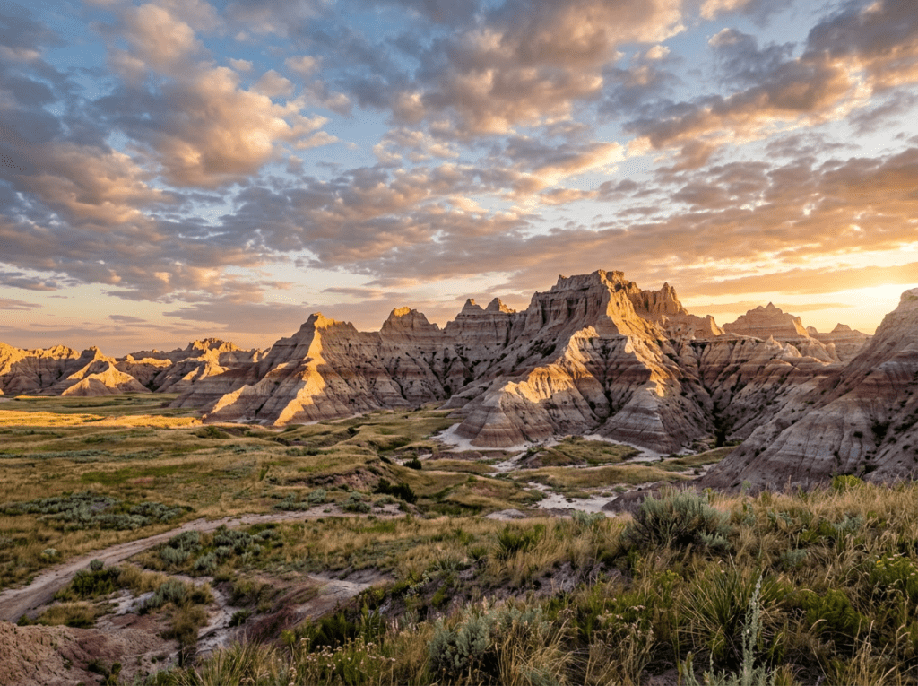
The color of the Badlands is what most visitors remember and most photographs fail to communicate accurately. The formations are not one color — they are dozens. Cream and tan in the upper sedimentary layers, deep burgundy and rust in the iron-rich bands below, lavender and gray in the volcanic ash layers, the whole spectrum shifting continuously as the light angle changes. At midday those colors flatten to a washed-out beige. At sunrise and sunset they deepen and saturate to something that looks almost impossible — the kind of color that makes first-time visitors stop mid-sentence and just look.
The park is not just the formations. The surrounding mixed-grass prairie — one of the largest protected prairie ecosystems remaining in North America — supports a wildlife population that is among the most visible and most accessible in the park system. Bison herds graze along the road corridor. Pronghorn antelope, the fastest land animal in North America, are present throughout the park. Black-footed ferrets, one of the most endangered mammals in North America, have been reintroduced in the Badlands and are active at dawn and dusk. And bighorn sheep navigate the formation faces with the casual ease of animals that have been doing exactly this for thousands of years.
The Photographer’s Chase
The Badlands formations face primarily south and east, which means the best light is directional and specific by time of day. Sunrise from the eastern overlooks — the Ben Reifel Visitor Center area and the overlooks along the eastern section of Badlands Loop Road — catches the first light raking across the formation faces from a low angle that builds extraordinary shadow and texture into the layered sedimentary bands. The color that is flat and undifferentiated at noon goes burgundy and rust and cream in warm saturated layers in that first thirty minutes of direct sun. I know this from the photographs of people who were there at dawn. I know it from the images I tried to manufacture in Photoshop from my midday originals. The next visit is about experiencing it in the field rather than reconstructing it on a screen.
The Notch Trail and the Door Trail, both accessible from the Door and Window parking area on Badlands Loop Road, are the hiking targets that get you away from the road corridor and into the formations on foot. The Notch Trail — a 1.5-mile round trip that involves a log ladder and an exposed traverse along a canyon ledge — reaches an elevated viewpoint looking out across the White River Valley and the prairie beyond the formations. The view from the notch at sunrise, with the formations below you and the prairie extending to the horizon, is the elevated Badlands perspective that the roadside overlooks cannot provide. The Door Trail, a short walk through a gap in the formation wall, enters the formation interior and provides the close-range geology photography — the layered sediment bands at eye level, the erosion patterns up close — that the distant overlook shots cannot.
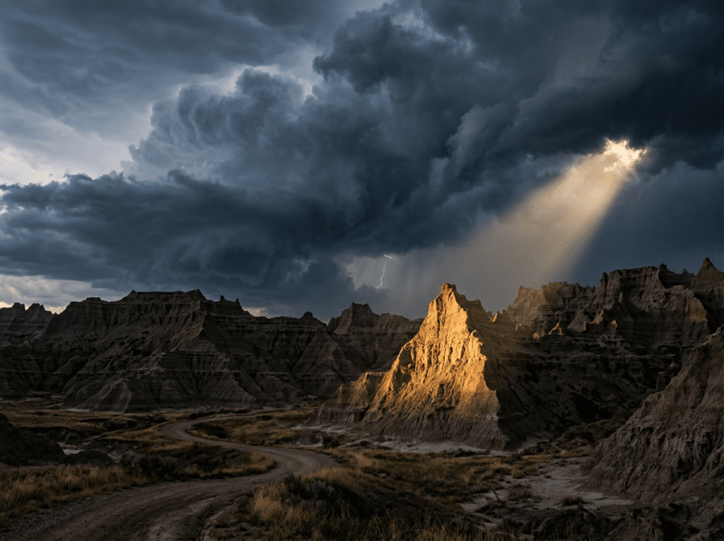
Storm light is the wild card that the South Dakota sky delivers more reliably than almost any other landscape in the park system. The Badlands sit in the middle of the Great Plains, where weather systems have an entire continent of open sky to build in, and the thunderstorm formations that develop over the formations in summer and fall can produce the most dramatic landscape photography light available anywhere in the Midwest. The formations under a dark storm sky, with a shaft of sun breaking through the clouds and illuminating a specific pinnacle while the rest stays dark — that image is worth positioning for. The exposure on open terrain during a Plains thunderstorm is real; stay aware of conditions and have a vehicle nearby. But the light in the break after a storm passes, when the air is washed clean and the wet formations are saturated with color and the sky is still dramatic behind them, is worth the patience.
Wildlife photography along the park road requires little effort and produces strong results. Pull over when bison are near the road and use a telephoto from inside the vehicle — the car functions as a blind and the bison are habituated to stopped vehicles in a way they are not to people on foot. A 100-400mm lens from a car window on a bison bull in the early morning light, with the formation wall behind him and the prairie grass catching the low sun, is a straightforward photograph that requires only positioning and patience.
Visiting the Park
A navigation note before anything else, because I earned it the hard way: the park has multiple entrances and they are not equally useful depending on where you are coming from and what you want to photograph. The Northeast Entrance off Exit 131 on I-90 near Wall, South Dakota, is the main entrance and the one that puts you directly on Badlands Loop Road with access to all the primary overlooks. The Interior Entrance off Highway 44 enters from the south and is less convenient for most visitors coming from I-90. Confirm your entrance before leaving the highway. The GPS does not always know which entrance serves your itinerary.
Late spring and fall are the strongest photography seasons. May and early June bring prairie wildflowers and the most active wildlife period — bison calves are born in late April and May, and the pronghorn fawns follow in June. September and October bring lower crowds, the possibility of early snow on the formations, and the low-angle autumn light that builds the most color and texture into the sedimentary bands. Summer brings the storm activity that produces the dramatic sky photography, but also the harshest midday heat and the highest visitor numbers.
No timed entry reservations are currently required. The park entrance fee applies; an America the Beautiful pass covers it. The park road — Badlands Loop Road — is a 32-mile circuit with all the major overlooks accessible from the car. Allow a full day minimum for the road with photography stops. Two days, with early morning and late evening sessions, is the minimum for doing the light justice.
Where to Stay
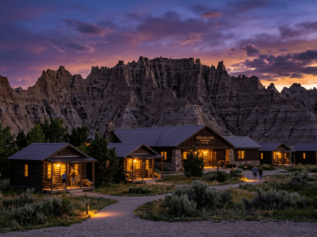
Cedar Pass Lodge, inside the park near the Ben Reifel Visitor Center, is the only in-park lodging and the right choice for photographers. The cabins sit within the park boundary, surrounded by the formations, and the distance between a cabin door and the nearest overlook is measured in walking minutes. Being inside the park at dawn — at the overlook before the light arrives, without a commute from Wall or Rapid City — is the practical advantage that makes the premium worthwhile. The lodge restaurant is the only dining inside the park; it is adequate, not remarkable, and worth knowing about before you arrive hungry after a long shooting day.
Wall, South Dakota — home of Wall Drug, the roadside institution that has been advertising on billboards across the Midwest since 1936 — is five miles from the northeast entrance and the most convenient outside base. It is a small town built primarily around the tourist trade and it is what it is, but the proximity to the park entrance makes early morning starts entirely practical. Rapid City, about 75 miles east, has the full range of chain hotels and the airport connections that make it the hub for longer regional trips combining the Badlands with Mount Rushmore, the Black Hills, and Wind Cave National Park.
Cedar Pass Campground inside the park is directly adjacent to the lodge and provides the closest camping to the formation overlooks. Sage Creek Campground in the park’s western unit is primitive — no hookups, no water, no fee — and positioned in the middle of the mixed-grass prairie where bison and pronghorn are regularly present at dawn. It is one of the more remote and more rewarding camping experiences in the Great Plains parks. RVs are accommodated at Cedar Pass; Sage Creek has no hookups and is best suited for self-contained rigs comfortable with primitive conditions.
If I Were Planning My First Visit
The first visit has already been made, and it taught me exactly what not to do. The second visit has a plan.
Two nights at Cedar Pass Lodge. Northeast Entrance confirmed before leaving the interstate. Arrival in the late afternoon of the first day — driving the Loop Road slowly in the pre-sunset light, finding the overlooks I want to return to before dawn, scouting the formation angles and the light direction without the pressure of shooting. The first look is always a look, not a session.
Dawn on both mornings, at the eastern overlooks, before the sun clears the horizon. A tripod, a wide angle for the formation panoramas and a telephoto for compressing the layered color bands. The Notch Trail on one of the mornings — arriving early enough to be at the notch viewpoint when the light hits the White River Valley below. And the prairie road in the early morning for the bison, slow driving, windows down, watching for the pronghorn in the grass.
And if the sky builds in the afternoon — if the Great Plains does what the Great Plains does and stacks clouds over the formations — I will stay out in it. Not recklessly. But long enough to find out what this landscape looks like when the weather is doing something interesting, which is what I should have stayed for the first time and did not.
The Light I’m Curious About
It is the dawn light I should have had the first time.
I have a specific image in mind — not a composition I planned, but one I saw in another photographer’s work and recognized immediately as the Badlands I did not find. The formations at first light, when the sun is still low enough that it is raking across the sedimentary layers at an almost horizontal angle, building the cream and rust and lavender into something saturated and dimensional and completely unlike the flat beige I photographed in the middle of the day. The shadow falling into every crevice and canyon. The color coming up in the bands the way color comes up in a darkroom print — slowly, then all at once.
I spent time in Photoshop on my first Badlands images trying to manufacture that light from what I had. You cannot manufacture it. You can only be there when it arrives — which means being at the overlook before it arrives, in the dark, waiting. Two nights at Cedar Pass makes that possible both mornings. I am not leaving until I have made that photograph.
A Deeper Exploration
This article is part of my ongoing project documenting and photographing all 63 national parks across the United States.
Along the way, I’m creating deeper guides that explore photography locations, travel planning, seasonal light conditions, and personal reflections from the road. The Badlands is the park in this project that has the clearest account of what went wrong the first time — and the clearest plan for what the return looks like. Sometimes the most useful thing a photographer can share is not the perfect image. It is the honest description of how they missed it, and what they intend to do differently.
Because the light was always there. It was just waiting for me to arrive at the right hour.
One more thing – just between us.
The Badlands Loop Road handles most of the park’s visitors efficiently and the overlooks deliver exactly what they promise. But here are three places worth knowing when you want the Badlands with more breathing room and more of the region’s full character.
The Sage Creek Wilderness Areain the park’s western section is accessed by the unpaved Sage Creek Rim Road and draws a fraction of the main loop’s traffic. The bison herds that graze the Sage Creek basin are free-ranging and frequently visible from the road at close range, the prairie dog towns are extensive, and the landscape has a rawness that the developed eastern section cannot match.
For the prairie and canyon photography that extends beyond the park boundary, Buffalo Gap National Grasslandsurrounds the park on three sides and provides the mixed-grass prairie landscape that the geological formations sit within — the wide open sky, the rolling grassland, and the occasional butte rising from the flats. Photographing the Badlands formations from the grassland approach rather than the parking lot overlooks changes the scale relationship completely.
And for the South Dakota experience that most Badlands visitors drive past on I-90 without stopping, the town of Wall and its famous Wall Drug Store is the roadside Americana landmark that has been advertising itself on billboards across the country since 1936. Absurd, genuine, and specific to this stretch of South Dakota highway. Worth twenty minutes and a camera before heading into the park. The Badlands were there before the billboards and they will be there after. But Wall Drug is part of the story of this place too.