A Photographer’s Return to the Pacific Coast — and the Night the Sky Turned Red Over Rialto Beach
Every photographer eventually builds a list of the moments they were in the right place at the right time. May 2024 on the coast of Washington State goes on that list.
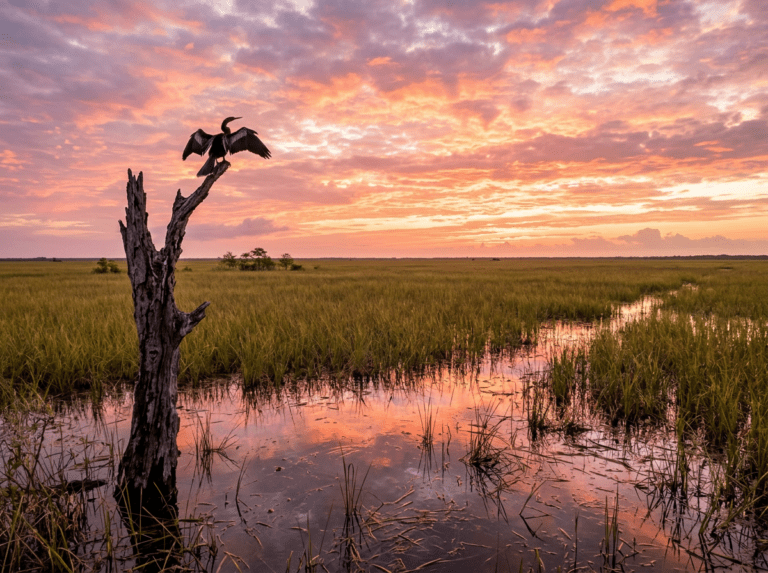
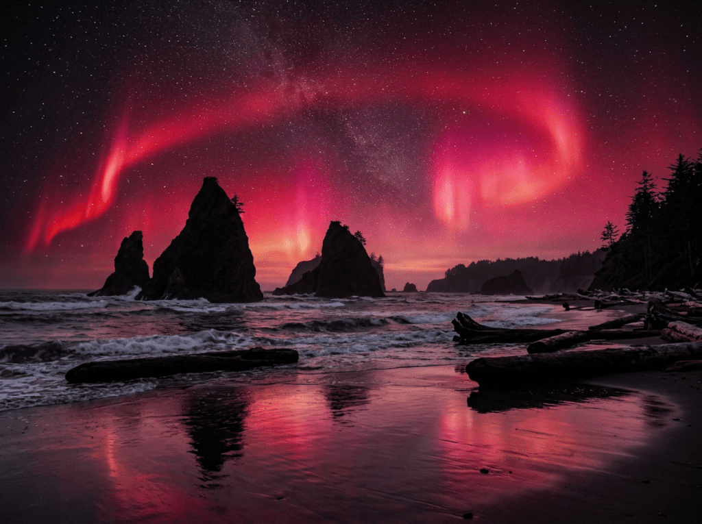
I was staying at a small inn in Gig Harbor — Washington was the first state of my 50 at 60 journey, the trip that set everything in motion — when the aurora alerts started coming in. I had been aware that a significant geomagnetic storm was building, but what the images showing up online made clear was that this was not an ordinary aurora event. The sky in the photographs was not the typical pale green curtain. It was a deep, saturated red that I had never seen in any aurora image before, a color so vivid and so unusual that it seemed almost artificial. The storm was a G5 — the strongest geomagnetic event in two decades — and it was driving the aurora down to latitudes far south of where it normally appears.
I got in the car and drove to Rialto Beach.
Rialto Beach sits on the wild Pacific coast of the Olympic Peninsula, a stretch of driftwood-strewn shoreline with the offshore sea stacks called the Quillayute Needles rising from the water and the full dark Pacific horizon to the west. I arrived as the sky was already doing something extraordinary — color building from the north, moving and pulsing in bands that went from that deep red through magenta and pink, the sea stacks silhouetted against it, the wet sand of the beach reflecting the color below. I photographed for two or three hours. The display did not fade. It deepened. It was the most extraordinary sky event I have ever witnessed with a camera in my hands, and it happened on a beach that is part of one of the most remarkable national parks in the system — a park I had been moving through too quickly to properly see.
The red color that made that aurora so unusual has a specific cause: during an extreme geomagnetic storm, the aurora descends to lower altitudes than normal, where oxygen molecules produce red light rather than the green that characterizes typical displays. It is rare. It is not something you can plan for or predict. You can only be in the right place when it happens — which means being in Olympic, on that coast, with the sea stacks and the dark horizon, as often as possible.
The Landscape That Draws People Here
Olympic National Park is three parks in one, occupying the Olympic Peninsula in the far northwest corner of Washington State — a landscape of such variety that it is difficult to believe it is contained within a single park boundary. The glacier-capped Olympic Mountains in the center of the peninsula rise to nearly 8,000 feet. The temperate rainforests on the western slopes of those mountains — the Hoh, Quinault, and Queets rainforests — receive up to 14 feet of precipitation annually, making them among the wettest places in the continental United States and producing the dense, moss-draped old-growth forest that is unlike anywhere else in the national park system. And the wild Pacific coastline, a 73-mile strip of protected wilderness beach and sea stack geology, is the most remote and undeveloped stretch of Pacific coast in the lower 48.
These three landscapes — alpine, rainforest, and coastal — are connected by roads but separated by character and photography logic. A day in the Hoh Rainforest has nothing to do with a day at Rialto Beach, which has nothing to do with a day on the Hurricane Ridge road above the treeline. They require different gear, different light expectations, and different patience. A single visit rarely does justice to more than one of them. Olympic rewards return trips the way few parks in the system do.
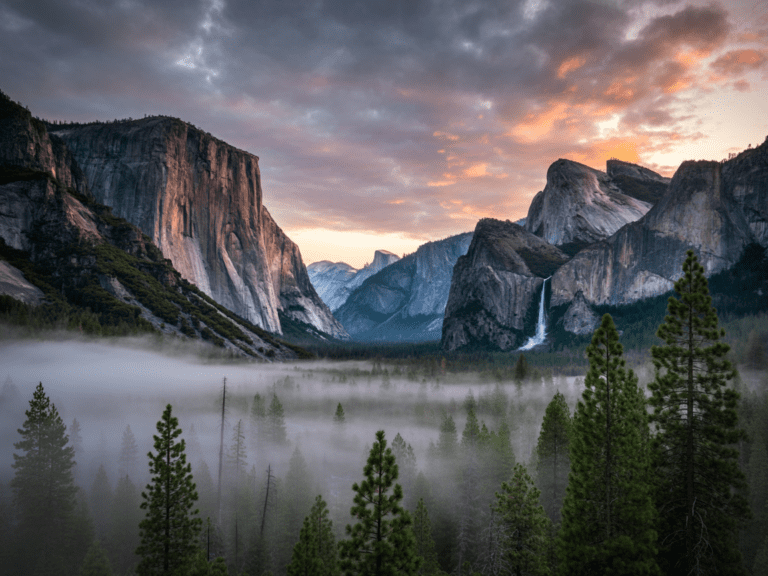
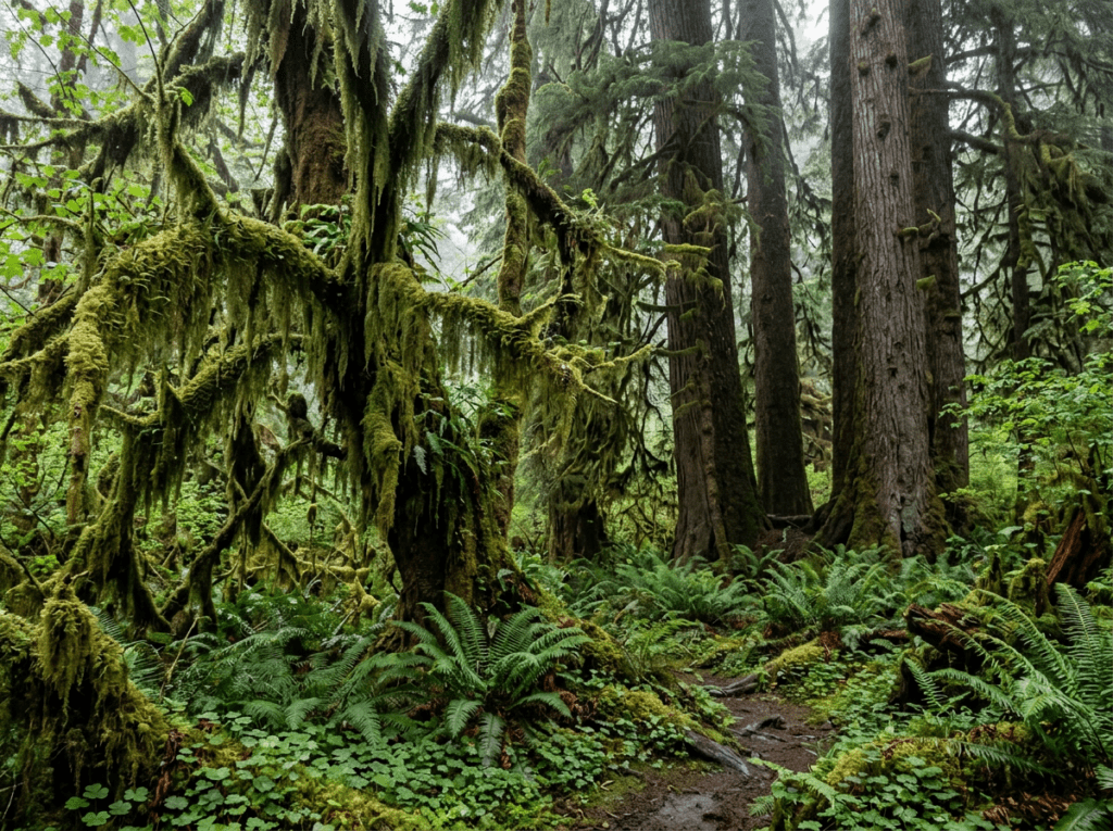
I spent time in the Hoh Rainforest on that first visit and I remember the green. The specific deep, saturated, almost luminescent green of a temperate rainforest in Pacific Northwest rain — the bigleaf maple branches draped in club moss, the fallen nurse logs carpeted in oxalis and fern, the Sitka spruce trunks rising into a canopy so dense it filters the light to a soft green-gray that exists nowhere else. I moved through it too quickly. I took photographs that recorded what I saw without capturing what the place felt like. The return trip is about going slower, staying longer, and letting the forest show me what it actually is.
The Photographer’s Chase
The three distinct landscapes of Olympic require three distinct photography approaches, and a serious photography trip plans for each one separately rather than trying to cover all three in a single pass.
The Hoh Rainforest is the intimate, close-range, wet-day photography — the kind of shooting that most photographers avoid when the clouds are low and the rain is falling and the light is flat. In the Hoh, that is the best possible condition. The overcast sky eliminates harsh contrast and saturates every shade of green to its maximum intensity. The moss on the bigleaf maple branches — thick, textural, hanging in curtains — photographs best when it is wet, when each individual moss frond is distinct and the whole canopy drips. A macro lens on the forest floor, at the base of a nurse log, in the rain, is where the defining Hoh Rainforest images live. Not on a sunny day. On the days most people stay in the car.
The coastal photography is governed by tide and light rather than weather. The sea stacks along the Olympic coast — at Rialto Beach, at Ruby Beach to the south, at Second Beach and Third Beach accessible by trail — are the primary subjects, and their photography is most powerful at low tide when the exposed tide pools and the rock shelves appear around the base of the stacks. Ruby Beach at sunrise, with the offshore stacks silhouetted against the eastern light coming through the sea mist and the tide pools reflecting the sky, is one of the Pacific Northwest’s most reliable strong landscape photography locations. Check the tide charts before every coastal visit — the difference between a high tide that covers the foreground interest and a low tide that reveals the tide pool platforms and the rock gardens is the difference between a good image and a great one.
Hurricane Ridge, the alpine zone accessible by a 17-mile road climbing from Port Angeles to 5,200 feet, provides the mountain photography that the rainforest and the coast cannot — panoramic views of the Olympic Mountains, subalpine meadows with wildflowers in July and August, and the possibility of clear-day photography that the western rainforest side of the park rarely offers. The Olympic Mountains create their own weather and the eastern side above Port Angeles receives significantly less precipitation than the western rainforest. Hurricane Ridge is where you go for the views. The Hoh is where you go for the green.
The aurora is the wildcard. Olympic’s coastal location, combined with the dark Pacific horizon and the sea stack foregrounds, makes it one of the finest aurora photography positions in the continental United States when the conditions align. The May 2024 event was extraordinary and unrepeatable in its specific character — but the solar cycle that produced it is not over. Solar maximum continues into the mid-2020s, and the probability of additional significant geomagnetic events is higher now than it will be for the next decade. Keep the aurora alerts active. Keep the Rialto Beach option in the back of your mind. Be ready to drive when the forecast says go.
Visiting the Park
Olympic’s geography requires planning that most parks do not. The park has no road that crosses it — the Olympic Peninsula’s mountainous interior means that reaching the different sections requires driving around the outside of the park, with the Hoh Rainforest on the western side, the coast access points scattered along the western edge, and Hurricane Ridge accessed from the north near Port Angeles. Driving from the Hoh to Rialto Beach to Hurricane Ridge in a single day is technically possible but leaves almost no time at any of them. Build the trip around one or two sections per day and accept that Olympic rewards multiple visits more than most parks.
Summer — July and August — brings the clearest weather to Hurricane Ridge and the best conditions for the alpine photography. The rainforest is accessible and productive year-round; fall and winter bring the heaviest precipitation and the most saturated green, and the crowds thin dramatically after Labor Day. The coastal photography is best in the shoulder seasons when the light is lower and the weather more dramatic — the Pacific Northwest coast in October, with storm systems moving in and the sea stacks in the low-angle autumn light, produces the most dynamic coastal photography the park offers.
A park pass is required. No timed entry reservations are currently required for most areas, though the Hoh Rainforest parking area fills early on summer weekends. The park road to Hurricane Ridge closes in winter and opens when conditions allow — check current road status at nps.gov/olym before planning a ridge visit outside the summer window.
Where to Stay
Port Angeles on the northern shore is the primary gateway city — a real working town with ferry connections to Victoria, British Columbia, and the closest urban base to Hurricane Ridge. The Colette’s Bed and Breakfast east of Port Angeles is the standout lodging choice on the peninsula — a waterfront property on the Strait of Juan de Fuca with views across to the Canadian mountains and a breakfast reputation that photographers on early-morning schedules find genuinely difficult to skip.
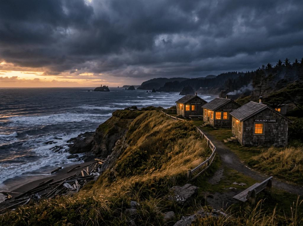
For the rainforest and coastal sections, Forks — the small logging town on the western peninsula that became unexpectedly famous — is the central base. The Hoh Rain Forest Resort and a handful of lodges along the US-101 corridor provide options close to the Hoh entrance and the coastal access trails. Kalaloch Lodge, on the coast inside the park south of Forks, is the only in-park coastal lodging — bluff-top cabins above the Pacific, the sound of the surf audible from the rooms, and some of the most dramatic storm-watching views on the Washington coast.
For RV travelers, the Olympic Peninsula has campgrounds throughout the park in all three zones — Hoh Campground in the rainforest, Mora Campground near Rialto Beach, and Kalaloch Campground on the coast are the primary options. The Hoh road has a 21-foot vehicle length limit that affects larger rigs; check current restrictions before routing a long rig to the rainforest. Gig Harbor and the greater Seattle area provide full hookup RV options for the trip start and end.
If I Were Planning My First Visit
The first visit has been made, in a blur of driving and early-trip energy and one extraordinary night at Rialto Beach that I did not fully plan for and will never fully forget. The return trip is slower and more deliberate.
A full day in the Hoh Rainforest — arriving early, moving slowly, spending time at the Hall of Mosses on a cloudy morning with a macro lens and no agenda beyond the green and the moss and the quality of light in a forest that receives twelve feet of rain a year. No rushing to the next overlook. Just the forest doing what the forest does, at the pace it has always operated.
A coastal evening at Ruby Beach for the sunset and the sea stacks. A tide chart checked the night before. A position at the water’s edge at low tide with the rock platforms and the tide pools in the foreground.
And the aurora alert active on my phone, every night I am on the peninsula. Because I was at Rialto Beach once when the sky turned red and lasted two hours, and I know what that coast looks like with the right light above it. It would be worth driving through the night to be there again.
The Light I’m Curious About
There are two, and they could not be more different from each other.
The first is the green light of the Hoh Rainforest in the rain — specifically the way overcast light filters through the moss canopy and arrives at the forest floor already saturated with green, so that everything in the frame is a shade of the same color, from the dark forest floor to the pale moss on the highest branches. I saw a version of this on the first visit and moved through it too quickly. The return is about being still inside it long enough for the place to reveal its textures and its layers. The Hoh in the rain, with a macro lens and a tripod and no particular hurry, is one of the photographic experiences I most want to have properly.
The second is another aurora. I do not expect the May 2024 event to repeat in its specific character — that red, that intensity, that duration. But the solar cycle that produced it continues, and the Olympic coast on a dark clear night with the aurora active is the finest aurora photography position I have personally stood in. I was there once. I want to be there again.
A Deeper Exploration
This article is part of my ongoing project documenting and photographing all 63 national parks across the United States.
Along the way, I’m creating deeper guides that explore photography locations, travel planning, seasonal light conditions, and personal reflections from the road. Olympic was the first park of the 50 at 60 journey — the place where I started learning what it means to travel slowly enough to actually see what you came for. I am still learning that lesson. The Hoh Rainforest is patient. It will still be there.
Because sometimes the park that started the journey is the one you most need to return to — with slower feet, better light, and the aurora alerts turned on.
One more thing – just between us.
Olympic is large enough and varied enough that most visitors spend their time on the main corridors — Hurricane Ridge, the Hoh Rainforest, Rialto Beach — and never reach the quieter sections that reward the extra drive. Here are three worth knowing.
The Quinault Rain Forest on the park’s southwestern edge is the less-visited counterpart to the Hoh — the same moss-draped bigleaf maple and Sitka spruce forest, the same overcast light that is ideal for rainforest photography, and a fraction of the Hoh’s visitor numbers. Lake Quinault Lodge, a 1926 property on the lake shore outside the park boundary, is the most atmospheric lodging in the Olympic Peninsula and the right base for the Quinault forest photography.
For the coastal section that most visitors driving US-101 pass without stopping, Kalaloch Beach and the Kalaloch Bluffs provide the most dramatic coastal cliff and sea stack photography on the park’s Pacific shore — particularly at low tide when the tidepools expose the intertidal zone and the light on the bluffs in the late afternoon produces the coastal photography that the more famous Rialto Beach cannot offer from the same angle.
And for the aurora photography that Rialto Beach delivered during the May 2024 G5 storm, the broader Washington coast is one of the most aurora-capable stretches of shoreline in the contiguous United States on high solar activity nights. Bookmarking the NOAA Kp index forecast and having Rialto Beach in the plan for any Olympic visit during elevated solar activity periods is the preparation that turns a landscape trip into the aurora photograph that most Olympic visitors never know is possible from a Washington beach.