A Photographer’s First Look at the Caribbean Park Where the National Park System Meets the Reef
Some landscapes become part of our imagination through work rather than vacation. I have spent time in the Caribbean on projects — a week living in an Airbnb in the Bahamas while lighting a high-end wedding, three containers of equipment shipped to the island, a golf cart as the primary mode of transportation between the venue and wherever the light needed to be. That week taught me something that no amount of travel photography research can substitute for: the Caribbean has a pace, and the pace is the point.
The golf cart pace. The unhurried morning. The way a day organizes itself around the light and the tide rather than a schedule. The specific quality of Caribbean air at 6am before the heat builds — clean and salt-tinged and somehow both tropical and clarifying at the same time. I have been to the Bahamas. I have worked in Puerto Rico. I know what the rhythm of the Caribbean feels like from the inside, and I am very much looking forward to arriving at Virgin Islands National Park with that rhythm already in my body rather than spending the first two days trying to find it.
Virgin Islands National Park covers about 60 percent of the island of St. John in the US Virgin Islands — 7,259 acres of tropical forest, white coral sand beaches, and the surrounding waters and coral reefs that make this one of the few national parks in the system where the primary photography subject is underwater. It is the second island territory park in this series after American Samoa, and the comparison is instructive. American Samoa is raw, remote, and barely visited. The Virgin Islands is more accessible — a ferry from St. Thomas, a developed tourist infrastructure in Cruz Bay, the Caribbean’s full amenity set within reach. But the park itself, particularly at the eastern end of the island and in the offshore waters, is genuinely wild. The reef here is among the healthiest in the Caribbean. The snorkeling at Trunk Bay and Waterlemon Cay is world-class by any measure. And the light on that water in the early morning is the Caribbean light I have been waiting to photograph properly.
The Landscape That Draws People Here
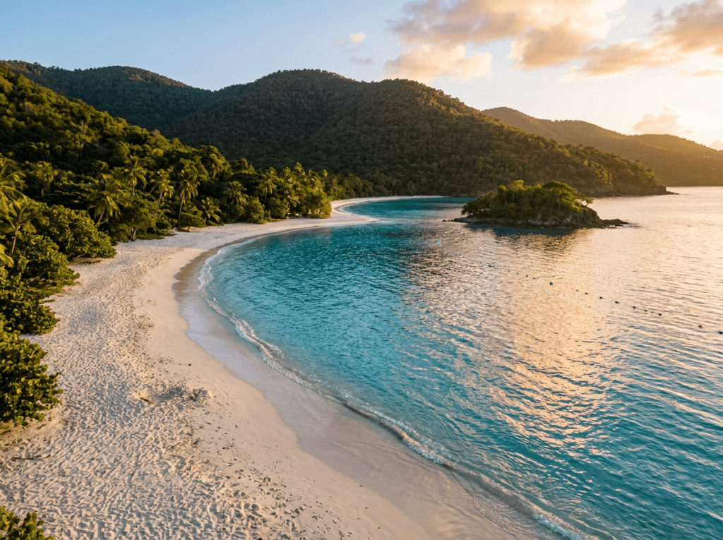
St. John is the smallest and least developed of the three main US Virgin Islands — St. Croix and St. Thomas are larger and more commercial, with the cruise ship infrastructure and the resort density that most Caribbean island tourism involves. St. John’s national park status has protected the majority of its land from that development, and the result is an island that still has the character of what the Caribbean looked like before the tourism industry arrived — forested volcanic hills dropping to white sand beaches, the water shifting from turquoise in the shallows to deep blue offshore, and the kind of quiet that the ferry ride from St. Thomas, once you leave the Charlotte Amalie harbor behind, begins to establish.
The park’s beaches are its most immediately photographed subjects, and they justify the reputation. Trunk Bay — frequently listed among the most beautiful beaches in the world — has a 225-meter underwater snorkeling trail marked with plaques identifying the coral and marine life, and the beach itself, backed by sea grape and palm and the green hills of the park above, photographs in the way that Caribbean fantasy beaches are supposed to photograph. Cinnamon Bay, longer and wilder, has ruins of a Danish sugar plantation at its edge — the human history of the island embedded in the landscape in a way that the pure beach photographs obscure. Waterlemon Cay, at the island’s east end accessible only by a trail through the forest, requires a swim to reach but delivers the least-visited snorkeling in the park.
The Reef Bay Trail — a 5-mile round trip descending from Centerline Road through dry forest and moist forest to the sea — is the park’s finest hiking experience and passes pre-Columbian petroglyphs carved into the rocks beside a freshwater pool near the trail’s end. The petroglyphs, made by the Taino people who inhabited these islands before European contact, are one of the most significant archaeological sites in the US Virgin Islands and are specifically and remarkably photogenic — the carved faces and symbols in the dark stone beside the pool, with the forest closing in and the sound of the sea below. A ranger-led version of this hike, offered seasonally, provides the historical context that the trail alone cannot.
The Photographer’s Chase
The Caribbean light in the early morning — before the sun climbs high enough to create the harsh overhead condition that flattens the water color and drives photographers to shade — is the window that defines the photography here. The light on the water at 7am in the Virgin Islands, when the sun is still low enough to rake across the surface and the turquoise of the shallows is most saturated, produces a color quality that no other time of day can replicate. The beaches before the visitors arrive. The reef in the first light before the water surface chop develops. That is when the photography happens.
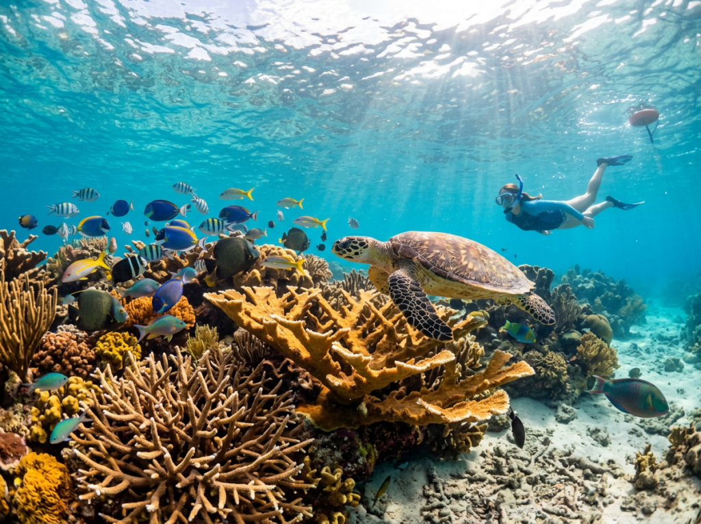
The underwater photography is the primary subject that separates this park from every other in the series. The coral reef at Trunk Bay and the more pristine reef at Waterlemon Cay supports elkhorn and staghorn coral, sea turtles, eagle rays, and the full complement of Caribbean reef fish in water clear enough that a snorkeler with an underwater housing can produce images at depths of 10 to 20 feet without significant light loss. The early morning snorkeling session — in the water before 8am when the surface is calm and the light penetration is at its best — is the reef photography window. A mirrorless body in a dedicated underwater housing, or a high-quality waterproof compact, is the right tool. The reef in that morning light, with the coral formations and the fish catching the filtered Caribbean sun, is the image that makes this park worth the ferry ride.
The elevated views from the park’s interior trails produce the landscape photography that the beach level cannot — the full sweep of a bay visible from the ridge above it, the green of the volcanic forest meeting the blue of the Caribbean, the neighboring islands of the British Virgin Islands visible across the Sir Francis Drake Channel. The Ram Head Trail at the island’s southern tip — a 1.8-mile round trip to a dramatic headland above the sea — provides the most exposed and most dramatic elevated coastal view in the park. The light from Ram Head in the late afternoon, with the channel below and the British islands on the horizon, is the wide landscape that contextualizes the whole island experience.
The plantation ruins — at Cinnamon Bay, at Annaberg on the north shore, and along the Reef Bay Trail — are the historical photography layer that most beach visitors never find. The Annaberg Sugar Mill ruins, accessible from the north shore road, are the most substantial and most photogenic — stone walls and arched doorways and the remains of the mill windmill tower, with the sea visible through the gaps in the masonry and the tropical vegetation reclaiming the structure at every joint. The late afternoon light on the Annaberg ruins, the stone going warm amber and the vegetation going gold around the edges, is the human history photograph that the beach shots cannot tell.
Visiting the Park
Getting to Virgin Islands National Park requires flying to St. Thomas — Cyril E. King Airport has direct service from several East Coast hubs including Miami, New York, and Charlotte — and then taking the passenger ferry from Red Hook on St. Thomas’s eastern end to Cruz Bay on St. John. The ferry runs frequently and takes about 20 minutes; a car ferry also operates but vehicle rentals are available on St. John itself, making the passenger ferry the practical choice for most visitors. Cruz Bay is the only town on St. John and the hub of island life — the ferry dock, the park visitor center, the restaurants and shops and the general energy of a small Caribbean community that has learned to coexist with a national park.
The primary season runs from December through April — the dry season when the rainfall is lowest, the visibility is best for underwater photography, and the crowds are highest. The shoulder seasons of May through June and November are the value windows — lower accommodation prices, manageable crowds, and weather that is warm and mostly dry. Hurricane season runs from June through November with peak risk in August and September; travel insurance is worth having for any Virgin Islands trip planned during this period.
Transportation on St. John is worth thinking about in advance. Open-air safari taxis — flatbed trucks with bench seating in the back — are the traditional island transport and are part of the experience rather than an inconvenience. Rental cars and jeeps are available in Cruz Bay and provide more flexibility for reaching the less-visited eastern end of the island and the Reef Bay trailhead. The island pace that makes St. John what it is starts with releasing the expectation of efficient transportation and embracing the golf-cart rhythm of a place that is not in a hurry.
Where to Stay
Cinnamon Bay Campground — inside the park on the beach of the same name — is the most distinctive accommodation option in the Virgin Islands and one of the more unusual lodging experiences in the national park system. Eco-tents and bare sites on a national park beach in the Caribbean, with the reef immediately offshore and the park trails accessible from the campground. It was closed for years after hurricane damage and has reopened in a more limited form; check current availability at recreation.gov before building a trip around it.
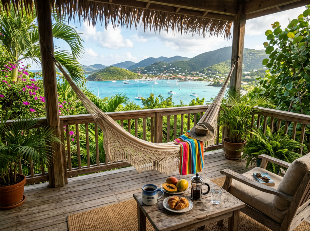
Cruz Bay has a full range of villa rentals, guesthouses, and small hotels that provide the Caribbean Airbnb experience — living inside the place rather than passing through it. The Westin St. John Resort Villas on the edge of Great Cruz Bay is the full-service resort option for those who want that infrastructure. But the rental villas scattered through the hills above Cruz Bay and along the north shore road, with their open-air porches and Caribbean views and the kind of slow morning that a rented kitchen and a local grocery store make possible — that is the accommodation style that matches the pace this island rewards.
There is no RV access to St. John — vehicles arrive by ferry and the island’s roads are narrow, hilly, and left-hand drive. This is a trip planned around villa rentals, safari taxis, and the particular freedom of having no vehicle larger than what fits on a ferry. For a photographer, that constraint is liberating rather than limiting. Everything you need fits in a camera bag and a daypack. The island does the rest.
If I Were Planning My First Visit
A full week minimum. Not a long weekend, not five days — a week, in a villa rental with a kitchen and a porch and the ability to watch the light change over the same bay at 6am and 7pm and understand what the island actually is across a full range of conditions.
The underwater housing packed and ready. An early morning snorkel session every day — in the water before 8am, at Trunk Bay or Waterlemon Cay, in the light before the surface chop develops and before the day visitors arrive on the ferry. The reef is the primary photography subject and it deserves the best light and the most time.
The Reef Bay Trail with a ranger for the petroglyphs. The Annaberg ruins in the late afternoon light. Ram Head at sunset for the wide channel view. And at least two mornings where the plan is simply to sit on the porch with coffee and watch the light arrive over the Caribbean and let the island set the pace.
That golf cart rhythm — the unhurried morning, the day organized around light and tide rather than schedule — is what the Caribbean offers and what this park specifically rewards. I have worked in the Caribbean enough to know that the people who get the most out of these islands are the ones who stop trying to see everything and start trying to understand one specific thing very well. A week on St. John with a camera and a snorkel mask and a kitchen and a porch is exactly that kind of trip.
The Light I’m Curious About
It is the early morning light on the Caribbean water — specifically the first hour of direct sun on the shallow reef, when the light is still low enough to rake across the surface and the turquoise of the shallows is at its most saturated and the underwater visibility is at its clearest before the day’s surface activity disturbs the water.
I have seen Caribbean light from above water many times — from a beach in the Bahamas, from a work site in Puerto Rico, from a porch in a rented house where the light on the water at 7am looked like something a colorist had approved rather than something the sun just did. What I have not done is be in that water with a camera when the light arrives. The reef in that morning light — the coral formations catching the filtered Caribbean sun, the fish moving through the color — is the image that the above-water Caribbean photography only hints at.
That is what the underwater housing is for. That is what the early alarm is for. And that is what the week-long rental is for — giving the light enough chances to arrive in the right condition, on the right morning, with me already in the water waiting for it.
A Deeper Exploration
This article is part of my ongoing project documenting and photographing all 63 national parks across the United States.
Along the way, I’m creating deeper guides that explore photography locations, travel planning, seasonal light conditions, and personal reflections from the road. Virgin Islands is the second island territory park in this series — the more accessible counterpart to American Samoa’s remoteness, and a park that makes its own case for what a national park can be when the landscape is underwater as much as it is above.
Because the Caribbean has a pace that the continental parks cannot replicate. And some photography — the best photography, sometimes — requires slowing down to the speed of the place you are trying to understand.
One more thing — just between us.
St. John is already the quieter island in the chain, but here are three places worth knowing when you want the Virgin Islands experience with even more room to find your own light.
Waterlemon Cay at the island’s east end — reached by a trail through the forest from the Leinster Bay parking area — requires a short swim to access and delivers the least-visited and most pristine snorkeling in the park. The reef around the cay is consistently rated the best in the national park and the absence of a beach means no day-trip crowds. Get there early and you will likely have it entirely to yourself.
For an above-water landscape experience away from the Trunk Bay scene, Salt Pond Bay on the island’s southern shore is a quieter beach with good snorkeling, a salt pond behind the beach that attracts shore birds, and the Ram Head trailhead for the dramatic headland photography.
And for a completely different perspective on the Virgin Islands, a day trip to Jost Van Dyke in the British Virgin Islands — a short boat trip from Cruz Bay — is the neighboring island that most captures the untouched Caribbean character that development is slowly changing elsewhere. The Great Harbour at Jost Van Dyke, with its handful of beach bars and its complete absence of resort infrastructure, is the Caribbean that existed before the tourism industry arrived. Worth a day and a camera.