A Photographer’s First Look at California’s Forgotten Volcano — and the Surprising Landscape It Created
When planning a visit to America’s national parks, California tends to pull attention toward the obvious — Yosemite, the Redwoods, Sequoia, Joshua Tree. The state has so many extraordinary parks that some of the finest ones get skipped indefinitely, not because they are not worth visiting but because the competition for attention is so fierce. Lassen Volcanic National Park is the clearest example of that. Sitting in the northeastern corner of California, off the main tourist corridors, it has been bypassed by generations of California visitors — myself included — who kept heading for the Sierra Nevada or the coast and never quite made the turn north.
Part of the beauty of this journey is not only retracing steps but planting new ones where I have not yet been. Lassen is one of those new ones, and the research I have done in preparation has consistently surprised me. My instinct going in was that this would be a dry, rocky, volcanic landscape — geologically dramatic but spare. That instinct is partially correct and mostly incomplete.
Lassen is all four types of volcano in a single park — plug dome, shield, cinder cone, and stratovolcano — making it one of the most geologically complete volcanic landscapes on earth. It has hydrothermal features that rival Yellowstone in their activity and variety. It has alpine meadows so dense with wildflowers in July that the volcanic origins of the soil seem impossible. It has pristine backcountry lakes of a blue that recalls Crater Lake. And yes, it has the stark volcanic terrain my gut was suggesting — the Devastated Area, where a 1915 eruption stripped the landscape to bare rock and downed timber that is still visible more than a century later. But the park is far more varied than the volcanic label suggests, and the photography range reflects that variety.
The Landscape That Draws People Here
Lassen Peak — at 10,457 feet the largest plug dome volcano on earth — is the park’s centerpiece and its most recent seriously active volcano. The 1914 to 1917 eruption sequence was the last significant volcanic activity in the contiguous United States before Mount St. Helens erupted in 1980, and the evidence of that activity is still dramatically visible in the landscape. The Devastated Area on the mountain’s northeastern flank shows the path of the 1915 eruption’s lateral blast — a swath of bare volcanic rock and fallen logs that has been revegetating slowly but still reads, more than a century later, as a landscape that something catastrophic passed through.
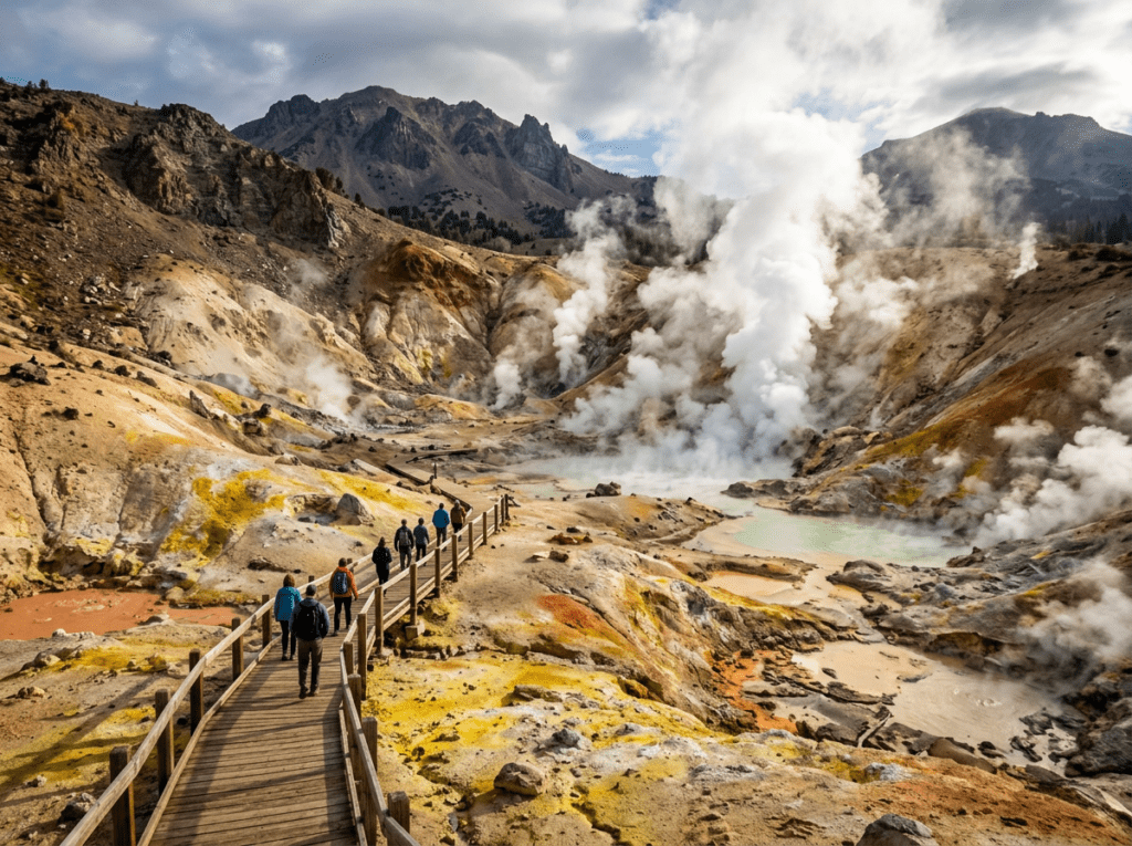
The Bumpass Hell hydrothermal area is the park’s Yellowstone equivalent — a 3-mile round trip hike to the largest hydrothermal area in the park, where boiling mudpots, steaming fumaroles, and acidic pools bubble and hiss in a landscape of yellow and orange and rust that looks like it belongs on another planet. The boardwalk system through Bumpass Hell keeps visitors safely above the thin crust that conceals scalding water below — the park is named for Kendall Bumpass, who discovered the area in 1865 and broke through the crust on a subsequent visit, badly burning his leg. The photography here, with the steam and the color and the otherworldly scale of the thermal activity, is some of the most visually extreme in the California park system.
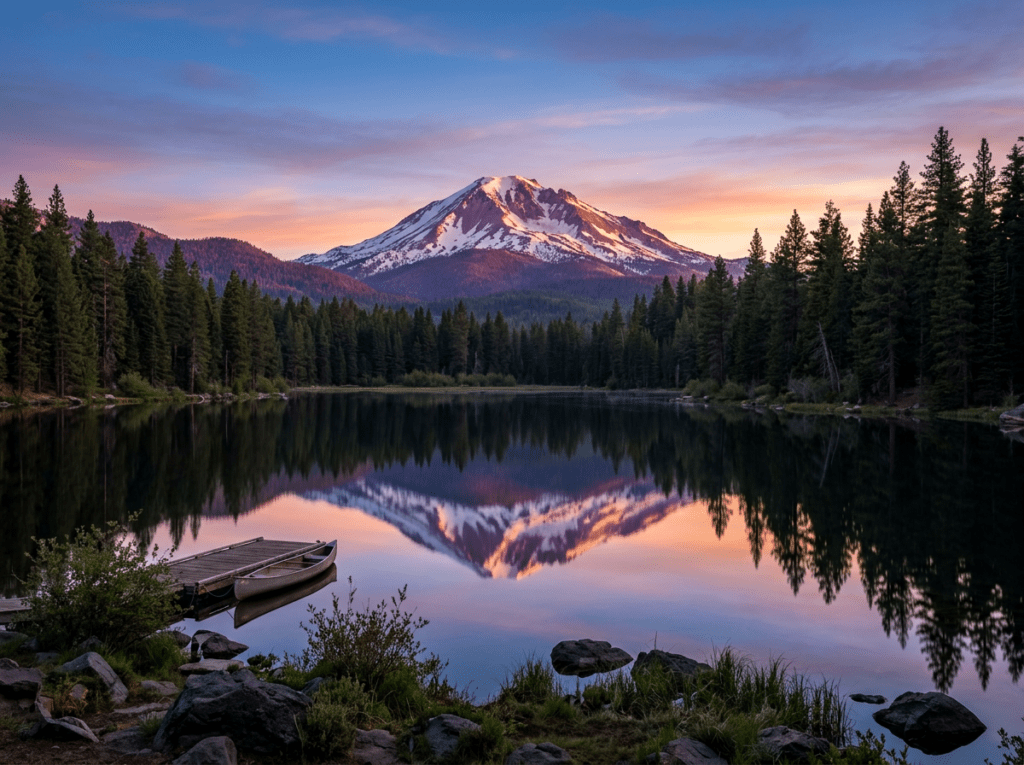
Manzanita Lake, in the park’s northwestern corner near the main entrance, is the alpine lake photography subject — a clear lake at 5,890 feet reflecting Lassen Peak across the water on calm mornings, with the volcanic cone framed by the surrounding forest and the peak’s reflection completing the symmetry. It is the establishing composition of the park and one of the finest mountain lake reflections in California. The Kings Creek Meadows in the park’s center are the wildflower destination — a broad subalpine meadow that peaks in July with lupine, paintbrush, and aster in the kind of alpine color display that the volcanic soil, apparently, is perfectly suited to produce.
The Photographer’s Chase
The Manzanita Lake reflection is the primary sunrise target and it operates on the same wind-and-calm logic as every mountain lake reflection in the park system. The window is pre-dawn, before the morning breeze develops on the lake surface — typically the first 30 to 45 minutes of light, when the peak catches the alpenglow above and the reflection below holds the color of the pre-dawn sky. The campground at Manzanita Lake puts you at the lake shore without a commute, which is the practical advantage for the 5am start the reflection requires.
Bumpass Hell is the hydrothermal photography and it requires a different approach from the lake work — the steam and the acidic pools and the color of the mineral deposits are best photographed in the morning before the afternoon wind develops and scatters the steam columns. The boardwalk positions you above the most active features and the telephoto lens isolates the boiling pools and the fumarole vents in a way that communicates the scale and the heat of the activity. A wide angle from the boardwalk captures the full Bumpass Hell basin — the yellow and orange of the sulfurous deposits, the steam columns, the barren volcanic landscape extending to the ridgeline above.
The Lassen Peak hike itself — 5 miles round trip with 2,000 feet of elevation gain — reaches the summit at 10,457 feet with views that extend to Mount Shasta to the north, the Sierra Nevada to the south, and the Sacramento Valley to the west. The summit photography on a clear morning, with the volcanic landscape of the park spread below and the distant peaks visible in multiple directions, is the elevated perspective that contextualizes everything seen at ground level. The hike is strenuous and the trail is snow-covered until mid-July in most years — check current conditions before planning a summit attempt.
The Devastated Area, accessible from a pullout on the main park road, is the volcanic history photography — the 1915 blast zone where the downed logs and the bare volcanic rock still read as aftermath rather than landscape, more than a century later. The morning light on the Devastated Area, with the standing snags and the volcanic rubble in the foreground and Lassen Peak above, is the geological narrative image that tells the story of what happened here in a way that the hydrothermal features cannot.
Visiting the Park
Lassen is a three-season park — the main park road, California Highway 89, crosses the park from the northwest entrance near Manzanita Lake to the southwest entrance near the Kohm Yah-mah-nee Visitor Center, and this road typically opens in late May or early June after snowplowing and closes again in October or November with the first significant snowfall. The road opening date varies by year and snowpack — check current road conditions at nps.gov/lavo before planning a visit that depends on full park access.
July and August are the peak season — the road is fully open, the wildflowers are at their peak in the meadows, the Lassen Peak trail is snow-free, and the Bumpass Hell hike is fully accessible. The crowds are present but manageable compared to the more famous California parks. September is the transition month — wildflowers fading, the first fall color arriving in the lower forest, the crowds thinning, and the light taking on the lower-angle quality that does the most interesting things to the volcanic terrain. September at Lassen has a strong case for being the finest photography month of the year.
No timed entry reservations are currently required. The park entrance fee applies; an America the Beautiful pass covers it. The nearest airports are Redding (RDD), about 50 miles west, and Sacramento (SMF), about 180 miles south — both serviceable for a fly-drive visit, with Sacramento providing the broader flight connections.
Where to Stay
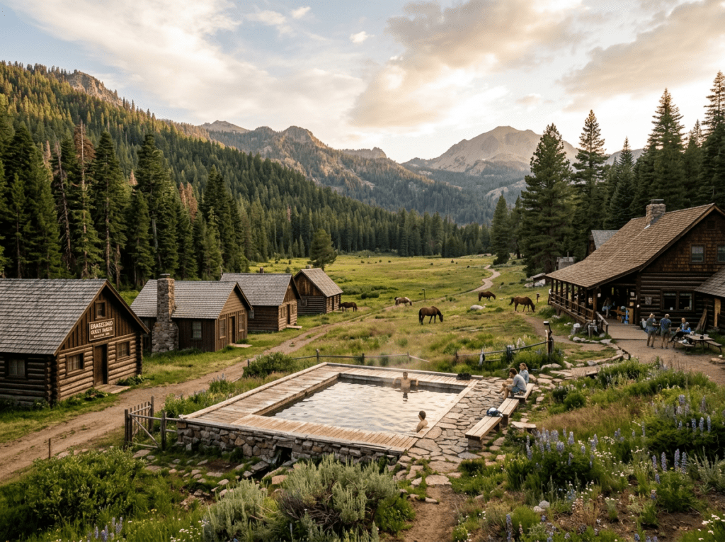
There is no traditional hotel lodging inside Lassen Volcanic National Park. The Drakesbad Guest Ranch, in the park’s Warner Valley backcountry area, is the only in-park accommodation — a historic working ranch accessible by a dirt road, with cabins and a natural hot spring pool, operating from early June through mid-October. It is remote, charming, limited in capacity, and books out well in advance for summer season. The experience of staying at Drakesbad — dinner at the communal table, the hot spring pool at night, the backcountry meadows immediately accessible — is specifically and distinctively Lassen in a way that no gateway town hotel can replicate.
The gateway communities of Chester to the southeast and Mineral to the southwest provide lodging options close to the park’s main entrances. The town of Chester, on Lake Almanor about 25 miles from the southwest entrance, is the more developed base with a reasonable range of independent lodging and the added photography bonus of Lake Almanor itself — a large reservoir lake with Lassen Peak visible across the water on clear days, producing a second mountain reflection composition entirely different from Manzanita Lake.
For campers and RV travelers, Manzanita Lake Campground inside the park is the prime location — directly on the lake, within walking distance of the reflection photography position, and reservable through recreation.gov for peak season. Summit Lake North and South campgrounds in the park’s center provide access to the Kings Creek Meadows and the Bumpass Hell trail. The park campgrounds accommodate standard RV sizes; the Drakesbad road is not suitable for RVs.
If I Were Planning My First Visit
Late July or September — the wildflower peak of late July or the quiet autumn light of September. Both have a strong case and the choice depends on whether the wildflower meadows or the fall color and solitude are the priority.
Manzanita Lake Campground for the in-park base. First morning at the lake before sunrise — in position on the shore in the dark, waiting for the alpenglow to touch the peak above and its reflection below. The same discipline as every mountain lake reflection in this series: be there before the light arrives, not after.
The Bumpass Hell hike on the second morning — early, before the afternoon wind develops, with a wide angle for the full basin and a telephoto for the individual thermal features. Then the Devastated Area in the late afternoon light, when the volcanic rubble and the standing snags catch the low sun and the whole blast zone becomes legible as a story rather than just a landscape.
And if the fitness and the snow conditions allow — the Lassen Peak summit. The park from 10,457 feet, with the volcanic terrain spread below and Mount Shasta on the northern horizon. The full picture of a landscape that California keeps bypassing on the way to somewhere else.
The Light I’m Curious About
It is the morning light in the Devastated Area — the specific quality of early sun on a landscape that a volcanic eruption stripped bare in 1915 and that has been slowly, partially, incompletely recovering ever since.
The downed logs in the Devastated Area are more than a century old and they are still there, bleached and silver, lying in the same direction the blast laid them down. The volcanic rock is still largely bare. New trees are growing but the landscape still reads as aftermath rather than forest — a geological wound that heals on geological timescales rather than human ones. The morning light raking across that landscape, the standing snags casting long shadows across the rubble and the new growth, Lassen Peak above in the early alpenglow — that is the image that tells the full story of what a volcano does to the world around it and how long the recovery takes.
My gut said dry and rocky. The research says so much more than that. The first visit will settle the question — and whatever the Devastated Area looks like in the early morning light of a September day, it will be more specific and more interesting than anything I have imagined from a distance.
A Deeper Exploration
This article is part of my ongoing project documenting and photographing all 63 national parks across the United States.
Along the way, I’m creating deeper guides that explore photography locations, travel planning, seasonal light conditions, and personal reflections from the road. Lassen is the California park that keeps getting skipped — passed over for Yosemite and the Redwoods and the desert parks to the south. The 63-park project exists precisely to correct that kind of oversight, one park at a time.
Because some of the most interesting light in California is falling on a volcanic landscape in the northeastern corner of the state that most California visitors have never seen. It has been waiting patiently. The drive north is worth making.
One more thing — just between us.
Lassen already runs quieter than most California parks, but here are three places worth knowing when you want the volcanic Northern California landscape with even more breathing room.
Lake Almanor — the large reservoir lake southeast of the park near Chester — offers a Lassen Peak reflection from the lake’s northern shore that is completely different from the Manzanita Lake composition and almost entirely unknown to park visitors. The mountain above the water on a still morning, with the lake stretching south and the surrounding ponderosa forest, is a strong landscape photography subject in its own right and a natural extension of the park visit.
Just north of the park, Mount Shasta — the massive stratovolcano visible from the Lassen summit — is 60 miles north and a completely different volcanic photography subject. The town of Mount Shasta at the mountain’s base, with the 14,179-foot peak rising directly above it, produces the mountain-above-the-town composition that few places in the American West can match.
And for a geothermal experience that extends the Lassen theme beyond the park boundary, Subway Cave— a lava tube just outside the park’s northern boundary on Highway 89 — is a free, self-guided walk through a 1,300-foot underground lava tube formed by the same volcanic activity that shaped the park. Dark, cool, geological, and completely unknown to most Lassen visitors. Bring a flashlight and a wide angle.