landscape photography

  • Storm Light in Channel Islands National Park

    I have driven the Pacific Coast Highway and remember islands visible from the road — though whether those were the Channel Islands or the more prominent Catalina Island closer to shore is genuinely uncertain from memory. The Channel Islands sit further out, 25 miles offshore from Ventura, and their distance from the coast is precisely what makes them extraordinary. Twenty-five miles of open Pacific creates a separation from the California mainland that feels, once you arrive on the islands, like a complete departure from the world you left behind at the harbor.

  • First Light at Petrified Forest National Park

    Some landscapes become part of our imagination long before we ever visit them. Petrified Forest National Park became part of mine before I could read — as a smooth, colorful, impossibly heavy piece of stone sitting in a bowl on a shelf at my grandparents’ house. I picked it up and asked what it was. They told me about a place in Arizona where ancient trees had turned to stone over millions of years, where the forest floor was covered in wood that was no longer wood — that had been replaced, molecule by molecule, by silica and iron and manganese until it held the shape and the grain of a tree trunk but rang like rock when you tapped it.

  • Finding Light in Guadalupe Mountains National Park

    Every photographer eventually builds a list of landscapes that exist in genuine geological relationship with each other. Guadalupe Mountains National Park and Carlsbad Caverns National Park are the above and below of the same ancient story — the Capitan Reef, a massive coral reef that grew at the edge of an inland sea 265 million years ago and now forms both the cave systems of Carlsbad and the mountain mass rising from the Chihuahuan Desert in West Texas.

  • The Light at Carlsbad Caverns National Park

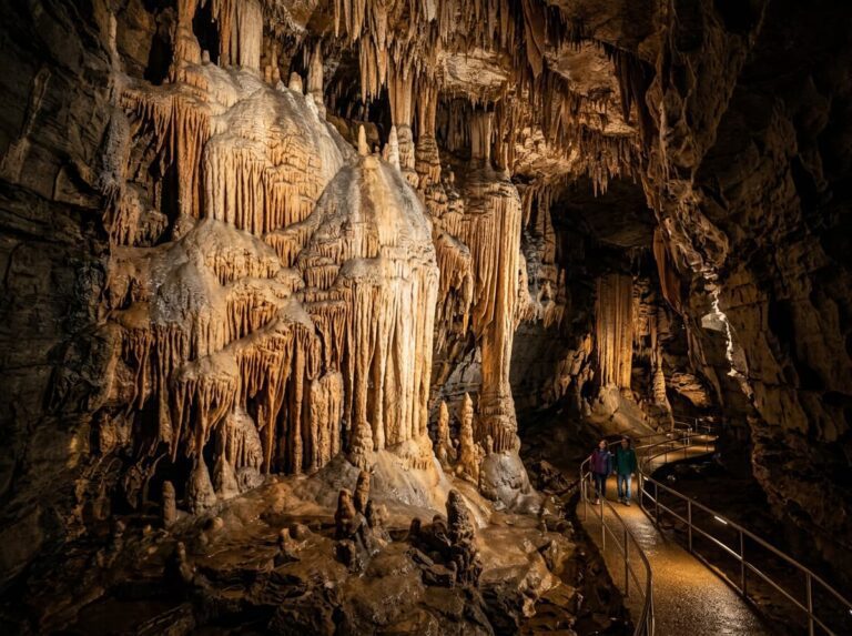
    The caverns sit beneath the Chihuahuan Desert of southeastern New Mexico, and what is underground there is not a modest geological curiosity. The Big Room — the main chamber of Carlsbad Cavern — is one of the largest cave chambers in North America, covering 8.2 acres at its widest and reaching 255 feet at its highest point. It contains stalactites, stalagmites, columns, draperies, popcorn formations, and cave pearls in a density and a variety that makes Laurel Caverns, wonderful as it is, feel like a preview of what a cave can actually be.

  • Finding Light in Glacier Bay National Park

    Some landscapes become part of our imagination through comparison. Glacier Bay National Park entered mine through Kenai Fjords — the Alaska park where a spontaneous boat tour became one of the most memorable experiences of my 50 at 60 journey. The tidewater glaciers calving into the fjord. The puffins on the sea stacks. The humpback whales surfacing close enough to feel the water move. If Kenai Fjords could produce all of that from a last-minute ticket at the Seward harbor, what might Glacier Bay — larger, more remote, more deliberately planned — produce with proper intention and preparation?

  • Chasing Light in North Cascades National Park

    Every photographer eventually builds a list of landscapes they drove away from. North Cascades National Park is on that list — east of Seattle, east of where I was headed when I flew into Washington to begin the 50 at 60 journey, east of the Pacific coast and Olympic that pulled me westward on that first trip. I could see the Cascade Range from the highway. I turned left instead of right and never made it.

  • Storm Light in Great Basin National Park

    The park sits in the Snake Range of eastern Nevada, about 300 miles from Las Vegas and 70 miles from the Utah border — as geographically isolated as any park in the contiguous United States. It receives fewer than 130,000 visitors a year, making it one of the least visited parks in the system. The nearest towns are tiny. The nearest city with an airport is hours away. The isolation that discourages most visitors is precisely what makes it extraordinary for photographers — specifically for the one thing Great Basin does better than almost any place in the continental United States: the night sky.

  • Inside Dry Tortugas National Park

    The waters surrounding the fort and the other Tortugas keys are among the clearest in Florida — the distance from any mainland development means minimal runoff and minimal light pollution, and the visibility underwater can exceed 100 feet on calm days. The coral reef along the southern and western edges of the park supports the same Caribbean reef ecosystem as Biscayne and the Florida Keys, with the added protection of extreme remoteness that keeps fishing and boat traffic minimal. Sea turtles — the green and loggerhead species that gave the islands their name — nest on the beaches of the outer keys and are regularly visible in the surrounding waters.

  • Finding Light in Capitol Reef National Park

    Capitol Reef is the middle child of the Utah parks — less famous than Zion and Bryce to the southwest, less visited than Arches and Canyonlands to the east, consistently overlooked in favor of its more celebrated neighbors. Most visitors to southern Utah drive Highway 24 through the park without stopping, catching a glimpse of the Waterpocket Fold from the road and continuing toward whichever more famous park is on the itinerary. This is a mistake.

  • The Light at Biscayne National Park

    Biscayne National Park protects 172,000 acres of southern Biscayne Bay, the upper Florida Keys, and the offshore coral reefs — making it one of the largest marine national parks in the system and the largest national park in Florida by area. The park’s above-water component is relatively small: a narrow strip of mangrove coastline on the mainland, the Dante Fascell Visitor Center at Convoy Point, and a chain of small islands — the northern Keys — that are accessible only by boat. Elliott Key, the largest island in the park, has a campground, hiking trails through tropical hardwood hammock forest, and the swimming beach at Hurricane Harbor.