A Photographer’s First Look at the Most Remote National Park in the United States — Where the Wilderness Is Not a Feature. It Is the Entire Point.
Some landscapes become part of our imagination through their absolute otherness. Gates of the Arctic National Park exists at the outer edge of what the national park system contains — not just geographically, though it sits entirely above the Arctic Circle in the Brooks Range of northern Alaska, but philosophically. This is the park that has no roads leading to it, no trails within it, no visitor facilities inside its boundaries, no entrance station, and no fee. It is 8.5 million acres of arctic wilderness — larger than Switzerland — where the only way to arrive is by small aircraft or by walking in from the Dalton Highway, and where everything that happens after arrival is entirely the visitor’s responsibility.
I am putting this one on the list with clear eyes about what it requires. Gates of the Arctic is not a park you visit the way you visit Yosemite or even the way you visit Katmai. It is a park you plan for months, prepare for seriously, and enter with the equipment, the skills, and the self-sufficiency of someone who understands that the nearest help is a long flight away and that the wilderness does not have emergency services on call. For a photographer who has worked through the 63-park project and arrived at this point in the journey, it is also one of the most extraordinary photography destinations on the planet — the Brooks Range in the arctic light of midsummer or the aurora of late August, the caribou migration crossing the river valleys, the Alatna and the North Fork of the Koyukuk rivers winding through a landscape that has no human infrastructure in any direction.
The name comes from Robert Marshall, a wilderness advocate who explored the Brooks Range in the 1930s and described two peaks flanking the North Fork of the Koyukuk — Frigid Crags and Boreal Mountain — as the gates to the arctic. He called them that because they marked the threshold beyond which the wilderness became absolute. They still do.
The Landscape That Draws People Here
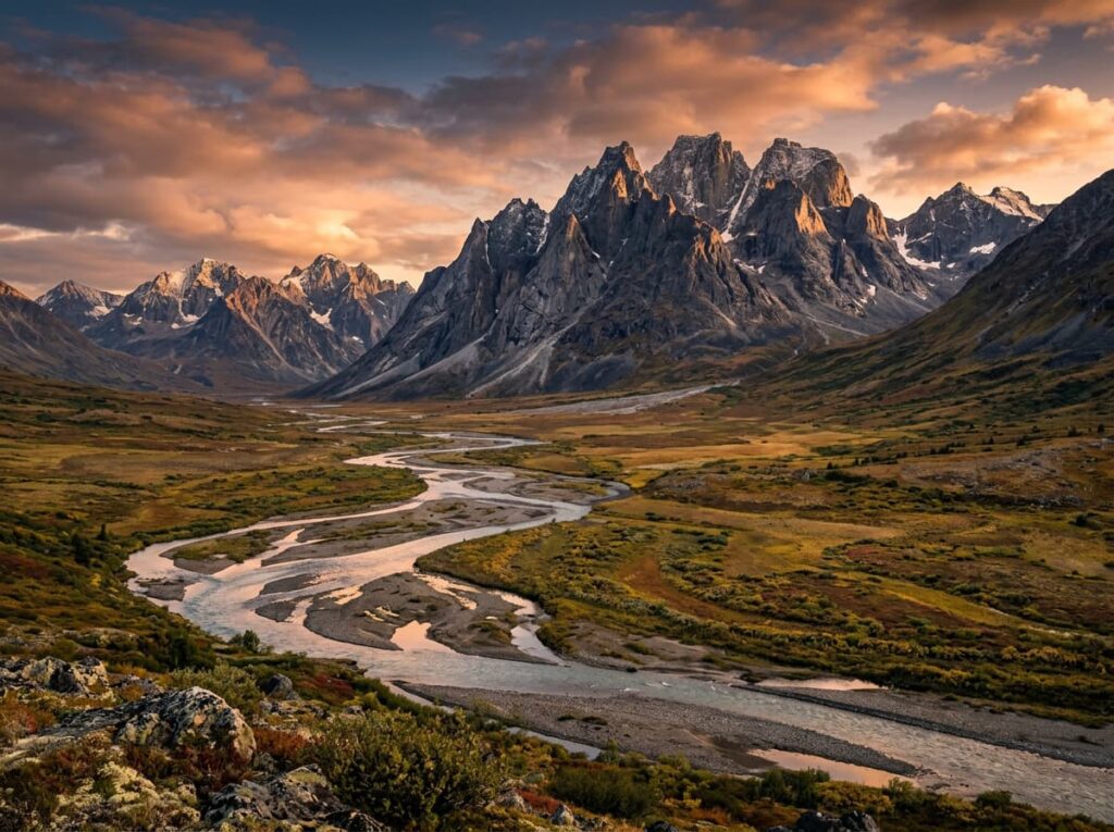
Gates of the Arctic National Park and Preserve covers 8.5 million acres of the Brooks Range — the northernmost mountain range in North America — and the river valleys and arctic tundra on both sides of the range. The park sits entirely above the Arctic Circle, which means the midsummer visitor experiences the midnight sun — 24-hour daylight in June and early July — and the late summer visitor experiences the first long twilights and the aurora. The landscape ranges from the jagged granite peaks of the Brooks Range to the braided river valleys of the north slope to the spruce and birch boreal forest of the south slope, all of it roadless and all of it managed as designated wilderness.
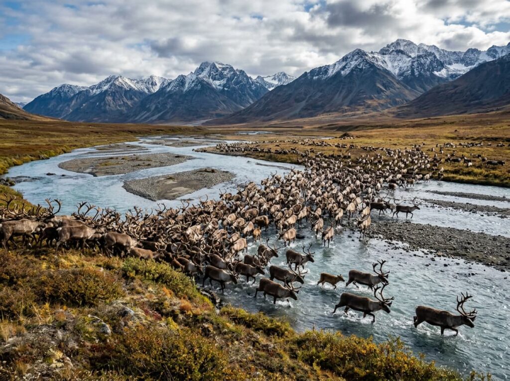
The wildlife is the full arctic portfolio — caribou in numbers that stagger the imagination during the migration, when herds of tens of thousands move through the river valleys in a river of antlers that can take hours to pass a single point. Grizzly bears in the river valleys and on the tundra slopes. Wolves in packs that range across territories measured in hundreds of miles. Dall sheep on the mountain ridges, their white coats visible from miles away against the gray rock. Golden eagles nesting on cliff faces. Arctic gyrfalcons. The wildlife of the Brooks Range is what the rest of Alaska’s wildlife looked like before the roads arrived.
The rivers are the access routes and the photography subjects simultaneously — the Alatna, the North Fork of the Koyukuk, the John River, and the Noatak drain the Brooks Range in different directions and provide the float trip routes that most serious Gates of the Arctic visitors use to move through the park. A multi-day float trip — put in by floatplane at a remote lake or river gravel bar, float the river to the takeout — is the primary way to experience the park’s scale and the primary framework for the photography that the landscape requires more than a day or two to find.
The Photographer’s Chase
The midnight sun photography is the midsummer condition that Gates of the Arctic offers and that no park in the lower 48 can replicate. In June and early July, above the Arctic Circle, the sun does not set — it circles the horizon continuously, dropping to its lowest angle around midnight and producing the most extraordinary golden hour light that lasts for hours rather than minutes. The Brooks Range peaks in the midnight sun, the arctic tundra going gold at 2am, the river surface catching the low-angle light at an hour when no photographer expects it — this is the light that defines midsummer arctic photography and that the short golden hours of the temperate parks cannot match in duration.
The caribou migration is the wildlife photography event that rivals Brooks Falls in its scale and surpasses it in its wildness — no platform, no managed viewing, just the river valley and the migration moving through it. The Western Arctic caribou herd numbers approximately 190,000 animals, and when the migration passes through the Gates of the Arctic river valleys in late spring or early fall, the landscape transforms into something from a different geological era. A telephoto from a river gravel bar, shooting into the herd as it crosses the river in front of you, produces wildlife images of a scale and a wildness that no managed wildlife viewing experience can approach.
The aurora photography from late August through the fall is the other primary target — the same aurora that Isle Royale offers, but above the Arctic Circle, with the Brooks Range as backdrop rather than Lake Superior. The absence of any artificial light within hundreds of miles produces a darkness that the word dark cannot adequately describe, and the aurora in that darkness, reflected in the still surface of an arctic lake or the braided channels of a tundra river, is the photography that the farthest reaches of the park system reserve for the people willing to go there.
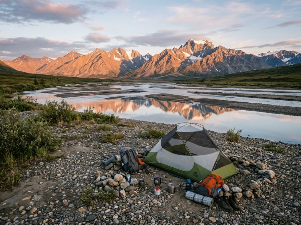
The float trip photography is the framework that makes sustained work possible — moving through the landscape by river over multiple days, setting up camp on gravel bars, waking to the arctic light at whatever hour it arrives, and having the patience of a multi-day wilderness trip rather than the urgency of a day visit. The river provides constant foreground — the braided channels, the gravel bars, the reflections of the peaks in the still pools — and the surrounding landscape changes continuously as the current moves downstream. A packraft or an inflatable canoe is the practical craft for a solo or small-group photography float; guided trips with Alaska float outfitters provide the logistics and the bear safety support for those new to arctic river travel.
Getting There — The Most Remote Access in the Park System
There are two ways to access Gates of the Arctic. The Dalton Highway — the gravel road that runs north from Fairbanks to Deadhorse on the Arctic Ocean — passes through the southern edge of the park and provides the only road-adjacent access. The town of Coldfoot, at mile 175 of the Dalton, has a ranger station with park information, a small visitor center, a fuel stop, and the last services before Deadhorse. Hiking into the park from the Dalton requires river crossings and navigation skills in a landscape with no trails and no marked routes — this is the most demanding and most committing approach and is appropriate only for experienced arctic wilderness travelers.
The floatplane is the practical access for most visitors — charter flights from Fairbanks, Bettles, or Coldfoot drop visitors at remote lake or river locations inside the park and arrange pickup at a designated takeout point after the trip. Bettles, a tiny community south of the park with a small lodge and an airstrip, is the primary staging point for floatplane access to the park’s interior. The Alaska Public Lands Information Center in Fairbanks is the essential first contact for trip planning — the rangers there provide current conditions, air taxi recommendations, bear safety requirements, and the Leave No Trace guidance that wilderness visitors to Gates of the Arctic must follow rigorously.
There is no RV access to the park interior — the Dalton Highway passes the park boundary but the park itself is roadless. The Dalton Highway is drivable in a standard vehicle in summer but is gravel, remote, and requires significant fuel planning — service stations are extremely limited between Fairbanks and Deadhorse. Driving the Dalton to Coldfoot and hiking or flying into the park from there is the most accessible approach for visitors without arctic float trip experience.
Where to Stay
Inside the park, there are no facilities — camping is entirely primitive, on gravel bars and tundra, with all food in bear canisters and all waste packed out. The wilderness camping experience at Gates of the Arctic is as complete and as unmanaged as the national park system offers.
Bettles Lodge, in the small community of Bettles south of the park, is the primary staging base — a historic Alaska bush lodge that has been hosting wilderness travelers since the 1950s. The lodge provides floatplane access coordination, local knowledge about river and weather conditions, and the kind of Alaska bush hospitality that makes the logistics of a remote wilderness trip feel manageable. Coldfoot Camp at mile 175 of the Dalton provides motel-style accommodation and is the base for visitors approaching via the highway.
Fairbanks, about 250 miles south of Coldfoot on the Parks and Dalton highways, is the logistics hub for the trip — the Alaska Public Lands Information Center, the floatplane charter operators, the gear outfitters, and the full range of lodging and services that a remote wilderness trip requires in preparation. A night in Fairbanks before and after the park trip is the practical bookend.
If I Were Planning My First Visit
This one requires the most honest self-assessment of any park in the project. Gates of the Arctic is not a park for a first-time Alaska wilderness visitor. The skills required — river navigation, bear safety in true wilderness, self-rescue capability, weather assessment, arctic camping — are real and consequential. The first visit to this park should be with a guided outfitter who provides the wilderness logistics and the safety infrastructure that a solo first-time visitor cannot.
A guided five-day float trip on the North Fork of the Koyukuk — put in by floatplane at a remote lake, float downstream through the Gates themselves between Frigid Crags and Boreal Mountain, take out near Bettles. The midnight sun in late June or early July for the extended golden hour light. The bears in the river valley and on the tundra above. The Dall sheep on the ridgeline. The camp on the gravel bar with the Brooks Range above and the river below and nothing else in any direction.
And if the timing aligns for the late August aurora — the first dark nights after the midnight sun season ends, the aurora appearing above the Brooks Range for the first time in months, the river reflecting it in the still pool beside the camp. That is the Gates of the Arctic image that sits at the furthest reach of this project. Twelve parks have brought me to this point in the journey. This one asks the most. It offers the most in return.
The Light I’m Curious About
It is the midnight sun light on the Brooks Range — the specific quality of golden hour that lasts for hours above the Arctic Circle in June, when the sun circles the horizon continuously and the peaks catch a light that the temperate parks receive for twenty minutes at best.
Every other park in this series has a golden hour that requires an alarm and a pre-dawn drive and careful timing. At Gates of the Arctic in midsummer the golden hour arrives around midnight and stays. The Brooks Range in that light — the low angle building shadow and texture into the granite ridgelines, the tundra going gold below, the river surface catching the sun at the angle that makes it look like hammered metal — is the arctic light that the temperate world cannot produce regardless of season or effort.
That light requires getting above the Arctic Circle, which requires the floatplane and the float trip and the self-sufficiency and the guide. This project has been building toward the edges of what is accessible and what is possible. Gates of the Arctic is the outer edge. The light there is worth everything the journey requires to reach it.
A Deeper Exploration
This article is part of my ongoing project documenting and photographing all 63 national parks across the United States.
Along the way, I’m creating deeper guides that explore photography locations, travel planning, seasonal light conditions, and personal reflections from the road. Gates of the Arctic is the park at the furthest reach of this series — the most remote, the most demanding, the most uncompromising in what it asks and what it offers. Every park before it in this project has been preparation in some sense. This one is the destination that the preparation is for.
Because the wilderness is not a feature at Gates of the Arctic. It is the entire point. And after 52 parks, I understand that well enough to go there properly.
One more thing — just between us.
Gates of the Arctic is already as far off the beaten path as the national park system goes. The insider tip here is about the approach corridor and the context parks that frame the experience.
The Dalton Highway drive from Fairbanks to Coldfoot is itself an extraordinary photography journey — the boreal forest transitioning to the Brooks Range foothills, the pipeline running alongside the road, the Yukon River crossing at mile 56, and the Finger Mountain tundra landscape at mile 98. The drive is the preparation and the re-entry, and it deserves to be driven slowly in both directions.
Kobuk Valley National Park — immediately west of Gates of the Arctic and the next park in this project’s remaining list — shares the same Brooks Range landscape and the same fly-in access but adds the Great Kobuk Sand Dunes, an active arctic sand dune field that produces one of the most surreal landscape photography subjects in Alaska. The two parks together tell the complete north-slope Brooks Range story.
And for the Fairbanks experience that frames the Alaska interior trip, the University of Alaska Museum of the North in Fairbanks has the finest collection of Alaska natural history and indigenous art in the state — the context it provides for the Brooks Range trip is the difference between entering a wilderness and understanding one. Worth half a day before the floatplane departs.